Approximate Location Map
Large Map »
Latitude: 54.9009 / 54°54'3"N
Longitude: -3.0373 / 3°2'14"W
OS Eastings: 333578
OS Northings: 556737
OS Grid: NY335567
Mapcode National: GBR 7C7R.7Y
Mapcode Global: WH801.92XQ
Plus Code: 9C6RWX27+93
Entry Name: Burial Ground Wall North of the Friend's Meeting House
Listing Date: 19 September 1984
Last Amended: 19 February 2010
Grade: II
Source: Historic England
Source ID: 1040006
English Heritage Legacy ID: 78259
ID on this website: 101040006
Location: Moorhouse, Cumberland, Cumbria, CA5
County: Cumbria
District: Carlisle
Civil Parish: Burgh by Sands
Traditional County: Cumberland
Lieutenancy Area (Ceremonial County): Cumbria
Church of England Parish: Burgh-by-Sands St Michael
Church of England Diocese: Carlisle
Tagged with: Building
NY 35 NW BURGH BY SANDS
MOORHOUSE
5/74 Graveyard Wall north
of the Friends'
Meeting House
(opposite side of
road)
II
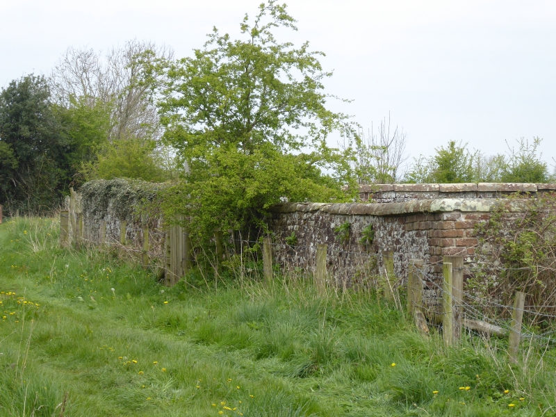
A Quaker burial ground wall built in 1694.
MATERIALS: Brick on a cobble foundation topped with rounded sandstone copings.
PLAN: The burial ground is rectangular in plan.
EXTERIOR: The burial ground consists of four walls raised slightly at the south west and south east corners with an entrance at the central part of the west wall. The entrance has a chamfered red sandstone surround to one side with a collapsed lintel dated 1694 and a collapsed sandstone surround partly blocking it. Elsewhere parts of the graveyard wall have collapsed, particularly on the east and part of the south side. The burial ground contains numerous simple inscribed stone gravemarkers.
HISTORY: The Society of Friends was formed in the mid C17. Moorhouse was an early and strong meeting; an earlier meeting house was built in 1681 and the acquisition of the burial ground was recorded in 1694 on land about 80m north of this. In 1733 the first meeting house was replaced by the present larger version, and at about the same time a boundary wall was built in front of the plot. The Moorhouse meeting was formally discontinued in 1913 and the meeting house served as a Methodist chapel until about 1967, after which it was sold and converted into a dwelling. The burial ground has been disused since 1936 and its wall has received little care or attention. Nevertheless unobtrusive repairs were made during the C20 with machine made bricks and some iron ties added to hold some of the coping stones. Despite these repairs some sections of the boundary wall have collapsed, including the majority of the eastern wall.
The meeting house was listed at Grade II in 1957. In 1984 the boundary wall fronting the meeting house was listed for group value at Grade II and at the same time the burial ground wall was listed at Grade II. At the site visit in December 2008 the lintel above the graveyard entrance and part of the entrance surround collapsed.
REASONS FOR DESIGNATION: The burial ground wall north of the Friend's Meeting House at Moorhouse is designated at Grade II for the following principal reasons:
* Along with the associated listed former Friend's Meeting House and its listed boundary wall, the burial ground wall remains a significant reminder of the importance of the Society of Friends in Moorhouse and the surrounding area between the late C17 and the early C20.
* The choice of materials used in its construction exemplifies the use of local materials and typifies the vernacular approach to construction taken by the Society of Friends
Listing NGR: NY3357856737
External links are from the relevant listing authority and, where applicable, Wikidata. Wikidata IDs may be related buildings as well as this specific building. If you want to add or update a link, you will need to do so by editing the Wikidata entry.


Other nearby listed buildings
