Approximate Location Map
Large Map »
Latitude: 53.3027 / 53°18'9"N
Longitude: -1.4744 / 1°28'28"W
OS Eastings: 435120
OS Northings: 378547
OS Grid: SK351785
Mapcode National: GBR LZ47.LS
Mapcode Global: WHDF2.B73X
Plus Code: 9C5W8G3G+36
Entry Name: Formerly the Building to the north-east of the Hall
Listing Date: 7 July 1989
Grade: II*
Source: Historic England
Source ID: 1040018
English Heritage Legacy ID: 79529
ID on this website: 101040018
Location: Dronfield, North East Derbyshire, S18
County: Derbyshire
District: North East Derbyshire
Civil Parish: Dronfield
Built-Up Area: Dronfield
Traditional County: Derbyshire
Lieutenancy Area (Ceremonial County): Derbyshire
Church of England Parish: Dronfield St John Baptist
Church of England Diocese: Derby
Tagged with: Building
This list entry was subject to a Minor Amendment on 20 June 2022 to update the name and address and to reformat the text to current standards
SK 37 NE
6/48
PARISH OF DRONFIELD
HIGH STREET (North Side)
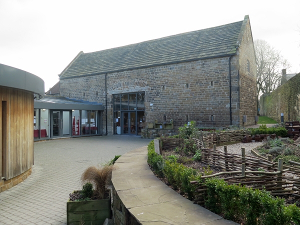
Dronfield Hall Barn
(Formerly listed as Building to the north- east of the Hall (No 19))
GV
II*
Storage building, formerly farm outbuilding. Late C17, but containing the substantial remains of a timber framed building, possibly the medieval hall. Coursed squared coal measures sandstone with coped gables and moulded kneelers, and a stone slated roof. L-plan, with former threshing door to central bay beneath a segmental relieving arch and a timber lintel. C20 boarded doors. Narrow ventilation slits or breathers at two levels and, on the west wall of the advanced bay, two doorways with quoined surrounds and substantial lintels to the ground floor, with a simple overloft doorway above, all with planked doors. King post roof, with through purlins, the tie beams and purlins having stop chamfers. At the junction of the main range and the added wing, an arched braced full height post with jowelled head stands on the line of the side wall. The wall plates now carried by the stone wall have mortices and peg holes for the former studs of the timber framed walling.
Listing NGR: SK3509378516
External links are from the relevant listing authority and, where applicable, Wikidata. Wikidata IDs may be related buildings as well as this specific building. If you want to add or update a link, you will need to do so by editing the Wikidata entry.


Other nearby listed buildings
