Approximate Location Map
Large Map »
Latitude: 53.1664 / 53°9'59"N
Longitude: -1.308 / 1°18'28"W
OS Eastings: 446362
OS Northings: 363478
OS Grid: SK463634
Mapcode National: GBR 7CJ.D4Z
Mapcode Global: WHDFQ.WNBX
Plus Code: 9C5W5M8R+HR
Entry Name: Range of Outbuildings and Stables, and Walls Enclosing a Courtyard to South of Hardwick Hall
Listing Date: 8 July 1966
Grade: II*
Source: Historic England
Source ID: 1051634
English Heritage Legacy ID: 79182
Also known as: Hardwick Hall Stables
ID on this website: 101051634
Location: Hardwick Park, Bolsover, Derbyshire, S44
County: Derbyshire
District: Bolsover
Civil Parish: Ault Hucknall
Traditional County: Derbyshire
Lieutenancy Area (Ceremonial County): Derbyshire
Church of England Parish: Ault Hucknall St John the Baptist
Church of England Diocese: Derby
SK 46 SE
10/12
8.7.66
PARISH OF AULT HUCKNALL
HARDWICK PARK
Range of Outbuildings & Stables, and walls enclosing a courtyard to South of Hall Hardwick
GV
II*
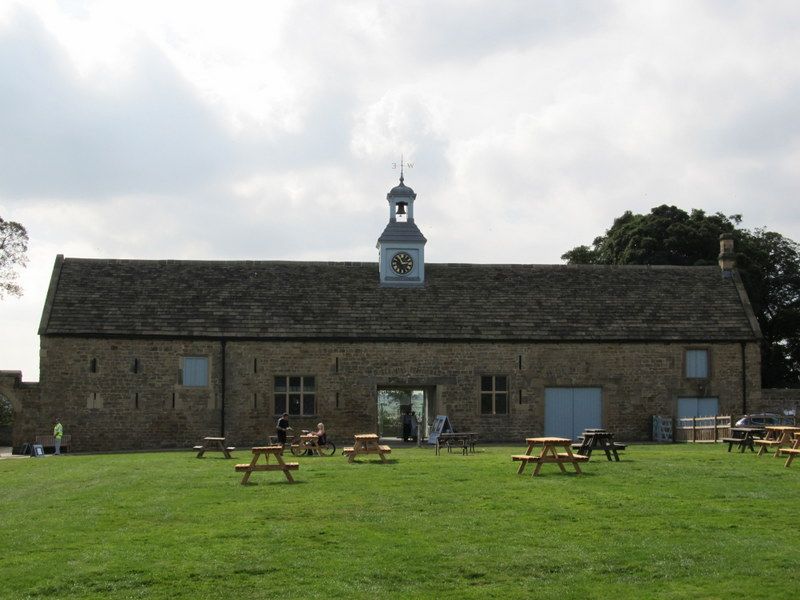
Range of outbuildings and stables. C17 and C19. Coursed squared sandstone with
sandstone dressings. Stone slate roofs with stone coped gables. Two ashlar ridge
stacks. Irregular one and two storey ranges, forming the south side of a large
enclosed courtyard. At the east end is a cart hovel with six openings divided by
stop-chamfered piers, which have elementary square bases and capitals. Shed at east
end with plank doors. To the west is a recessed symmetrical two-bay unit. Central
doorway with chamfered ashlar surround and segmental relieving arch. Plank door.
Flanked by 3-light recessed and chamfered mullioned windows. Return wall to the
right has a pair of blind round-arched entrances with windows set in. Projecting six
bay range to west has plain doorways and two tiers of two and three light mullioned
windows; the upper windows smaller than the lower. To the right is a round-arched
opening with stepped gable, into a courtyard. Principal range to the west was under
scaffolding at the time of writing. Various doorways and mullioned windows. Central
clock turret in two square stages. The lower stage contains the clock, and has a
pyramidal roof narrowing to the upper, bell-stage. Ogee roof and weather vane.
Listing NGR: SK4636263478
External links are from the relevant listing authority and, where applicable, Wikidata. Wikidata IDs may be related buildings as well as this specific building. If you want to add or update a link, you will need to do so by editing the Wikidata entry.


Other nearby listed buildings
