Approximate Location Map
Large Map »
Latitude: 51.4812 / 51°28'52"N
Longitude: -0.1228 / 0°7'22"W
OS Eastings: 530448
OS Northings: 177472
OS Grid: TQ304774
Mapcode National: GBR JR.L6
Mapcode Global: VHGR5.T1FC
Plus Code: 9C3XFVJG+FV
Entry Name: The Vat House, Flats 1 to 16
Listing Date: 29 July 1977
Last Amended: 11 November 1999
Grade: II
Source: Historic England
Source ID: 1064949
English Heritage Legacy ID: 204630
ID on this website: 101064949
Location: South Lambeth, Lambeth, London, SW8
County: London
District: Lambeth
Electoral Ward/Division: Oval
Parish: Non Civil Parish
Built-Up Area: Lambeth
Traditional County: Surrey
Lieutenancy Area (Ceremonial County): Greater London
Church of England Parish: South Lambeth St Anne and All Saints
Church of England Diocese: Southwark
Tagged with: Building
TQ 3077 REGENTS BRIDGE GARDENS
963/7/850 The Vat House, flats 1-16
29-JUL-1977
GV II
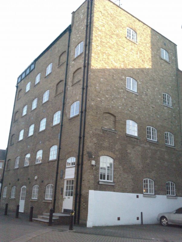
Former vat house and clock tower, now flats. Circa 1810, clock tower altered 1916 after fire. Refurbished and converted to flats, 1980's. Formerly Beaufoy Vinegar Works. Stock brick with stone dressings. Flat roofs. Timber clock tower and cupola. Three storeys, seven uneven bays to side elevations. Ground and first floor segmental headed openings, inserted entrance in south elevation. Upper floor rectangular openings with flat lintels. Continous first floor storey band. Tall cylindrical chimney to north. Symmetrical west elevation in three bays, three storeys and attic. Central entrance rising through two storeys flanked by segmental headed openings. Similar openings to third storey. Attic storey small opening in recessed semicircular arch, set in tall brick parapet with flanking swept gables. Stone cornice and blocking course. Rectangular timber rusticated clock tower on shallow base, clock to each face. Above, timber cupola of eight Doric columns supporting copper dome. Bell inscribed THOMAS MEARS LONDON FOUNDER 1843. Former water tower to east. Five storeys in stock brick with iron plates of tank above. Segmental headed openings to five bay east elevation and three bay south elevation., some blank. Interior converted to flats.
Cherry and Pevsner, London, 2: South, 1983, p.370
Survey of London, Vol.XXVI, pt.II, 1956, p.69
Listing NGR: TQ3044877472
External links are from the relevant listing authority and, where applicable, Wikidata. Wikidata IDs may be related buildings as well as this specific building. If you want to add or update a link, you will need to do so by editing the Wikidata entry.


Other nearby listed buildings
