Approximate Location Map
Large Map »
Latitude: 52.4272 / 52°25'37"N
Longitude: -0.9526 / 0°57'9"W
OS Eastings: 471318
OS Northings: 281540
OS Grid: SP713815
Mapcode National: GBR BSW.S05
Mapcode Global: VHDR5.F8S4
Plus Code: 9C4XC2GW+VX
Entry Name: 9, High Street
Listing Date: 19 July 1985
Grade: II
Source: Historic England
Source ID: 1067035
English Heritage Legacy ID: 360270
ID on this website: 101067035
Location: Clipston, West Northamptonshire, LE16
County: West Northamptonshire
Civil Parish: Clipston
Built-Up Area: Clipston
Traditional County: Northamptonshire
Lieutenancy Area (Ceremonial County): Northamptonshire
Church of England Parish: Clipston All Saints
Church of England Diocese: Peterborough
Tagged with: Building
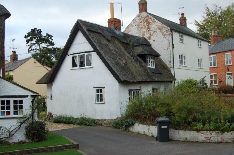
CLIPSTON HIGH STREET
SP7081 (West side)
15/17 No.9
GV II
House. Probably early C18. Timber framed with stone plinth and cob infill.
2-unit plan. Single storey with attic. Ground floor, 3-window range of
casements. Single roof dormer. Central brick stack. Left gable has evidence of
timber frame. C20 extension with entrance to rear.
Listing NGR: SP7131881540
External links are from the relevant listing authority and, where applicable, Wikidata. Wikidata IDs may be related buildings as well as this specific building. If you want to add or update a link, you will need to do so by editing the Wikidata entry.


Other nearby listed buildings
