Approximate Location Map
Large Map »
Latitude: 51.4099 / 51°24'35"N
Longitude: -0.3053 / 0°18'19"W
OS Eastings: 517960
OS Northings: 169239
OS Grid: TQ179692
Mapcode National: GBR 78.ZN7
Mapcode Global: VHGR8.NTGJ
Plus Code: 9C3XCM5V+XV
Entry Name: Former Old Crown Public House
Listing Date: 19 August 1982
Grade: II
Source: Historic England
Source ID: 1080095
English Heritage Legacy ID: 203091
ID on this website: 101080095
Location: Kingston upon Thames, London, KT1
County: London
District: Kingston upon Thames
Electoral Ward/Division: Grove
Parish: Non Civil Parish
Built-Up Area: Kingston upon Thames
Traditional County: Surrey
Lieutenancy Area (Ceremonial County): Greater London
Church of England Parish: All Saints, Kingston-on-Thames
Church of England Diocese: Southwark
Tagged with: Pub
(Formerly listed as The Old Crown Public House)
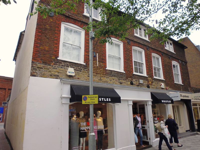
Early to mid 18th century facade. Reputed to have timber frame, perhaps of 17th century. The front is of three storeys, with five windows on the first floor and three on the second floor. On the ground floor is a C19 pilastered pub front of little interest, with, to the right, a carriageway which has been filled in with a further modern pub front. The upper floors are faced with brown brick with red brick dressings to the first floor windows. First floor windows are segmental arched with slightly recessed sash boxes. The second floor windows have three casements each. There is a brick band at second floor level. Tiled roof. The rear and sides are rendered and gabled. Some timber framing survives on the upper floors.
Listing NGR: TQ1796069239
This list entry was subject to a Minor Amendment on 15/03/2018
Kingston upon Thames, historically in Surrey, was an important market town, port and river crossing from the early medieval period, while there is evidence of Saxon settlement and of activity dating from the prehistoric period and of Roman occupation. It is close to the important historic royal estates at Hampton Court, Bushy Park, Richmond and Richmond Park. The old core of the town, around All Saints Church (C14 and C15, on an earlier site) and Market Place, with its recognisably medieval street pattern, is ‘the best preserved of its type in outer London’ (Pevsner and Cherry, London: South, 1983 p. 307). Kingston thrived first as an agricultural and market town and on its historic industries of malting, brewing and tanning, salmon fishing and timber exporting, before expanding rapidly as a suburb after the arrival of the railway in the 1860s. In the later C19 it become a centre of local government, and in the early C20 became an important shopping and commercial centre. Its rich diversity of buildings and structures from all periods reflect the multi-facetted development of the town.
External links are from the relevant listing authority and, where applicable, Wikidata. Wikidata IDs may be related buildings as well as this specific building. If you want to add or update a link, you will need to do so by editing the Wikidata entry.


Other nearby listed buildings
