Approximate Location Map
Large Map »
Latitude: 52.2362 / 52°14'10"N
Longitude: -2.0738 / 2°4'25"W
OS Eastings: 395055
OS Northings: 259786
OS Grid: SO950597
Mapcode National: GBR 2H2.QJF
Mapcode Global: VHB05.02H0
Plus Code: 9C4V6WPG+FF
Entry Name: Former barn and granary about 27 metres south of Shell Manor
Listing Date: 4 September 1986
Grade: II
Source: Historic England
Source ID: 1081213
English Heritage Legacy ID: 147849
ID on this website: 101081213
This list entry was subject to a Minor Amendment on 13 April 2022 to update name and address, amend description due to change of use of building and to reformat text to current standards
SO 95 NE
7/173
HIMBLETON CP
SHELL
Swifts Cottage, The Swallows Nest, The Hay Barn and The Ponies
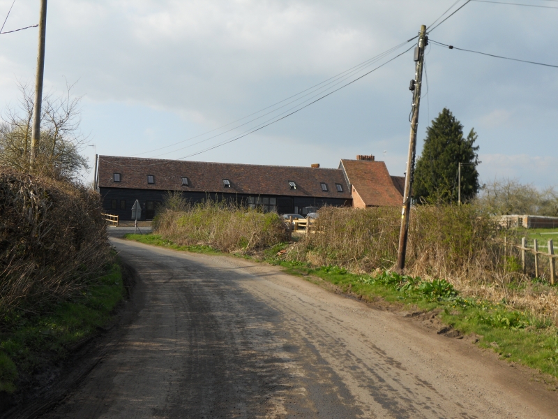
Former barn and granary about 27 metres south of Shell Manor
(Formerly listed as Barn and granary about 30 yards south of Shell Manor, SHELL)
GV II
Former barn and granary. C17 with mid-C19 additions. Timber-framed and weatherboarded with a plain tiled roof. Six framed bays aligned north-east/south-west; third bay from north-east end is a wagon bay with opposed cart entries and double doors. Main north-west elevation has four stable doors, one at left side and three in the two bays to the right.
Framing: wall-frame of long rectangular panels; north-east bay has three rows of panels from sill to wall-plate and short straight upper braces; collar and tie-beam trusses throughout with struts; intermediate trusses are arch-braced; single tier of trenched purlins. A C19 brick granary adjoins the north-east gable end; the north-west elevation has a stable door on the ground floor and blue and red brick steps to upper level door; also first-floor three-light wood mullioned window.
Interior: roof has two king-post trusses. Outshut to south-west elevation. The buildings enclose the east side of the former farmyard situated in front of Shell Manor (qv).
Listing NGR: SO9505559786
External links are from the relevant listing authority and, where applicable, Wikidata. Wikidata IDs may be related buildings as well as this specific building. If you want to add or update a link, you will need to do so by editing the Wikidata entry.


Other nearby listed buildings
