Approximate Location Map
Large Map »
Latitude: 51.3427 / 51°20'33"N
Longitude: 1.421 / 1°25'15"E
OS Eastings: 638347
OS Northings: 165958
OS Grid: TR383659
Mapcode National: GBR X0F.L36
Mapcode Global: VHMCW.LJ21
Plus Code: 9F338CVC+39
Entry Name: Gate House to Cemetery About 50 Metres South of Cemetery Chapel, with Side Walls
Listing Date: 4 February 1988
Grade: II
Source: Historic England
Source ID: 1085436
English Heritage Legacy ID: 171712
ID on this website: 101085436
Location: Ramsgate Cemetery, West Dumpton, Thanet, Kent, CT11
County: Kent
District: Thanet
Civil Parish: Ramsgate
Built-Up Area: Ramsgate
Traditional County: Kent
Lieutenancy Area (Ceremonial County): Kent
Tagged with: Gatehouse
TR 36 NE
1/83
RAMSGATE
CECILIA ROAD
(north side)
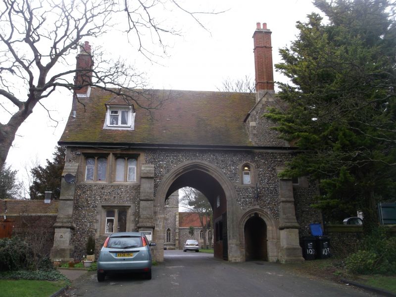
Gate House to cemetery about 50 metres south of Cemetery Chapel, with side walls
GV
II
Gatehouse. 1872 by G.G. Scott. Flint with dressed stone and with timber
framing in gables, brick interior walls and plain tiled roof. Two
storeys and attic with 3 offset moulded buttresses and moulded brick
stacks to end left and to front right. Hipped dormer. Paired 2 light
arched windows to left on first floor with single 2 light below, and
with 2 single cusped lights on first floor to right. Central carriage
arch with wave mouldings, and cast iron gates, with pedestrian arch to
right, with plank and stud and grilled door. Single storey hipped
L-shaped outbuilding adjoining to left. Interior passageways of brick,
with plastered ceilings and granite set flooring. Rear elevation with
two 2-light windows on 1st floor, 1 to right on ground floor, with
irregular openings elsewhere, and brick external stair with iron handrail
to arched plank and stud door on left return. Plank and stud door to
right in outbuilding. Lengths of wall flank the entrance front, of
flint capped with brick, about 7 feet high, extending some 10 metres
to left, and returned forward 15 metres to a pier, and similarly 10
metres and projecting 10 metres to a pier to right. (See Homan, Victorian
Churches of Kent, 83).
Listing NGR: TR3834765957
External links are from the relevant listing authority and, where applicable, Wikidata. Wikidata IDs may be related buildings as well as this specific building. If you want to add or update a link, you will need to do so by editing the Wikidata entry.


Other nearby listed buildings
