Approximate Location Map
Large Map »
Latitude: 50.9217 / 50°55'18"N
Longitude: -1.4742 / 1°28'27"W
OS Eastings: 437053
OS Northings: 113715
OS Grid: SU370137
Mapcode National: GBR 768.0E8
Mapcode Global: FRA 76SN.ZD0
Plus Code: 9C2WWGCG+M8
Entry Name: 65, Test Lane
Listing Date: 22 April 1981
Grade: II
Source: Historic England
Source ID: 1091975
English Heritage Legacy ID: 135938
ID on this website: 101091975
Location: Redbridge, Southampton, Hampshire, SO16
County: City of Southampton
Electoral Ward/Division: Redbridge
Parish: Non Civil Parish
Built-Up Area: Southampton
Traditional County: Hampshire
Lieutenancy Area (Ceremonial County): Hampshire
Church of England Parish: Maybush
Church of England Diocese: Winchester
Tagged with: Building
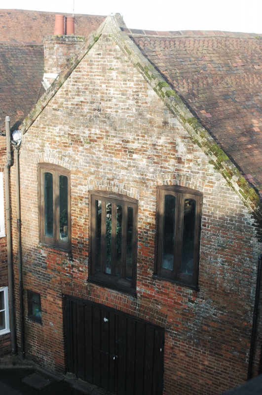
1. TEST LANE
5239 Redbridge
No 65
SU 31 SE 9/242 22.4.81
II GV
2.
Formerly an outbuilding to the Anchor Hotel. Early C18. Two storeys and
attics red brick. Old tiled roof. Gable end with brick coping and kneelers.
First floor has sashes with glazing bars intact and cambered heads. Large
cambered door to ground floor.
Listing NGR: SU3705713710
External links are from the relevant listing authority and, where applicable, Wikidata. Wikidata IDs may be related buildings as well as this specific building. If you want to add or update a link, you will need to do so by editing the Wikidata entry.


Other nearby listed buildings
