Approximate Location Map
Large Map »
Latitude: 53.3288 / 53°19'43"N
Longitude: -1.6359 / 1°38'9"W
OS Eastings: 424348
OS Northings: 381385
OS Grid: SK243813
Mapcode National: GBR KY0Y.MF
Mapcode Global: WHCCN.VL6D
Plus Code: 9C5W89H7+GM
Entry Name: Scraperlow Farmhouse and Attached Outbuildings
Listing Date: 19 February 1985
Grade: II
Source: Historic England
Source ID: 1109792
English Heritage Legacy ID: 81164
ID on this website: 101109792
Location: Hathersage Booths, Derbyshire Dales, Derbyshire, S32
County: Derbyshire
District: Derbyshire Dales
Civil Parish: Hathersage
Built-Up Area: Hathersage
Traditional County: Derbyshire
Lieutenancy Area (Ceremonial County): Derbyshire
Church of England Parish: Hathersage St Michael and All Angels
Church of England Diocese: Derby
Tagged with: Farmhouse
SK 28 SW PARISH OF HATHERSAGE
2/54
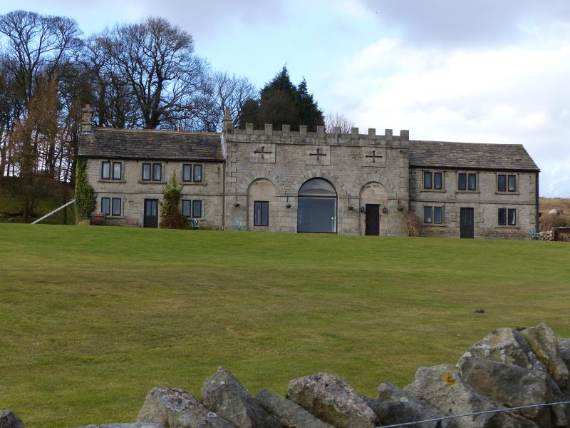
Scraperlow Farmhouse
and attached outbuildings
II
Farmhouse and attached outbuildings. Early C19 remodelling of an earlier C18
range, in order to create a balanced facade. Coursed rubble gritstone, with
ashlar dressings, projecting quoins, plain gables, end ridge stacks to house
part at west end, and stone slated roofs. House and outbuilding in line,
remodelled as castellated central range with flanking domestic ranges. South
elevation; two storeys, nine bays, the three western bays forming the house part,
with 2-light flush mullioned windows, now with C20 casements. Plain band course
above ground floor windows continues along the length of the whole facade.
Central doorway with projecting quoined surround and C20 half glazed door.
Outbuildings; the three eastern bays exactly match the three western bays, but
the openings have been blocked. There is a cart entrance to the east gable with
a segmental arched head, and above, a pitching eye in a square stone surround.
The central three bays have a high castellated parapet rising in front of a
pitched roof, with cruciform embrasures in ashlar panels above three tall openings
with keyed semi-circular arches, the smaller flanking arches having ashlar infil
with doorways, the central arch remaining open, and with a lower, and earlier
segmental arch to the inner face of the opening.
Listing NGR: SK2434881385
External links are from the relevant listing authority and, where applicable, Wikidata. Wikidata IDs may be related buildings as well as this specific building. If you want to add or update a link, you will need to do so by editing the Wikidata entry.


Other nearby listed buildings
