Approximate Location Map
Large Map »
Latitude: 51.465 / 51°27'53"N
Longitude: -1.0396 / 1°2'22"W
OS Eastings: 466812
OS Northings: 174438
OS Grid: SU668744
Mapcode National: GBR Q3B.N8
Mapcode Global: VHCZ9.XFRS
Plus Code: 9C3WFX76+X5
Entry Name: 26, Armour Hill
Listing Date: 14 December 1978
Grade: II
Source: Historic England
Source ID: 1113393
English Heritage Legacy ID: 38744
ID on this website: 101113393
Location: Tilehurst, Reading, Berkshire, RG31
County: Reading
Electoral Ward/Division: Kentwood
Parish: Non Civil Parish
Built-Up Area: Reading
Traditional County: Berkshire
Lieutenancy Area (Ceremonial County): Berkshire
Church of England Parish: Tilehurst St Michael
Church of England Diocese: Oxford
Tagged with: Building Thatched cottage
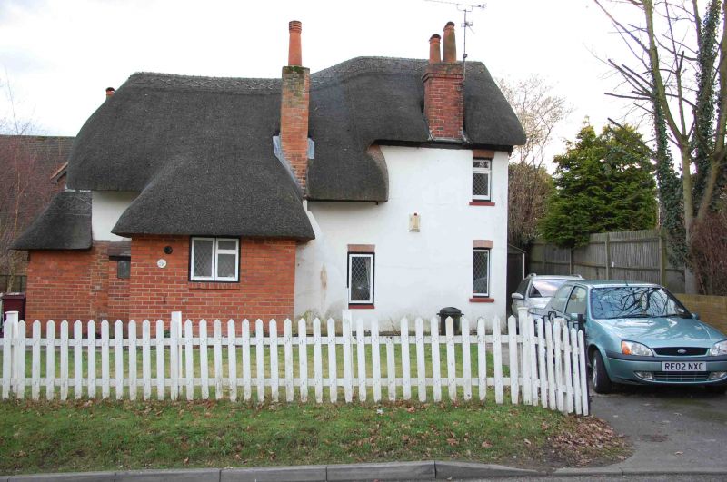
ARMOUR HILL
1.
5128
No 26
SU 67 SE 16/402
II
2.
C17 altered and modernised. 1 1/2 storey thatched cottage. Rendered (over timber-
frame probably). To north large catslide with bread oven and 2 storey extension
to right. Entered from east in thatched porch with window over. Included
as a survival from the old hamlet of Armour-Tilehurst.
Listing NGR: SU6681274438
External links are from the relevant listing authority and, where applicable, Wikidata. Wikidata IDs may be related buildings as well as this specific building. If you want to add or update a link, you will need to do so by editing the Wikidata entry.


Other nearby listed buildings
