Approximate Location Map
Large Map »
Latitude: 52.2113 / 52°12'40"N
Longitude: -0.5865 / 0°35'11"W
OS Eastings: 496677
OS Northings: 257950
OS Grid: SP966579
Mapcode National: GBR DZQ.8K7
Mapcode Global: VHFPS.SP95
Plus Code: 9C4X6C67+GC
Entry Name: Odell Estate Office
Listing Date: 27 August 1987
Grade: II
Source: Historic England
Source ID: 1114322
English Heritage Legacy ID: 37077
ID on this website: 101114322
Location: Odell, Bedford, Bedfordshire, MK43
County: Bedford
Civil Parish: Odell
Traditional County: Bedfordshire
Lieutenancy Area (Ceremonial County): Bedfordshire
Church of England Parish: Odell
Church of England Diocese: St.Albans
Tagged with: Building
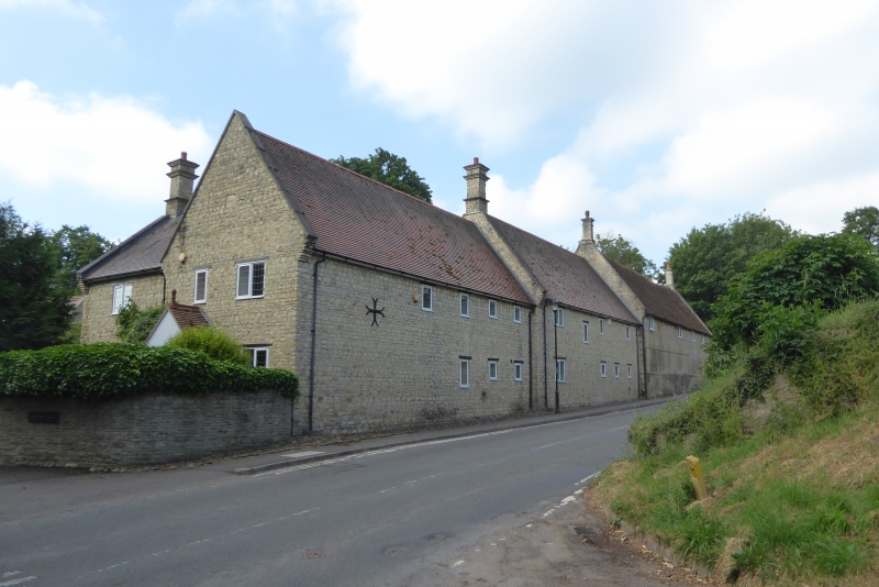
ODELL HIGH STREET
SP 9657 (South Side)
10/307 No. 61 Odell Estate Office
-
- II
Late C17 or early C18 converted barn adjacent to Odell Castle. Coursed
limestone rubble, old clay tile roof with stone coped gable ends. Two
storeys. Street elevation has four small high 2-light casements with leaded
panes: row of eight slit openings below; plinth. West gable end has 2-light
casement with timber lintel over.
Listing NGR: SP9667757950
External links are from the relevant listing authority and, where applicable, Wikidata. Wikidata IDs may be related buildings as well as this specific building. If you want to add or update a link, you will need to do so by editing the Wikidata entry.


Other nearby listed buildings
