Approximate Location Map
Large Map »
Latitude: 54.5546 / 54°33'16"N
Longitude: -1.9786 / 1°58'42"W
OS Eastings: 401484
OS Northings: 517709
OS Grid: NZ014177
Mapcode National: GBR GHMS.F2
Mapcode Global: WHB4C.LS17
Plus Code: 9C6WH23C+VH
Entry Name: The Grove
Listing Date: 17 June 1986
Grade: II
Source: Historic England
Source ID: 1121027
English Heritage Legacy ID: 111273
ID on this website: 101121027
Location: Lartington, County Durham, DL12
County: County Durham
Civil Parish: Lartington
Traditional County: Yorkshire
Lieutenancy Area (Ceremonial County): County Durham
Tagged with: Building
LARTINGTON LARTINGTON GREEN LANE
NZ 0117
(North side)
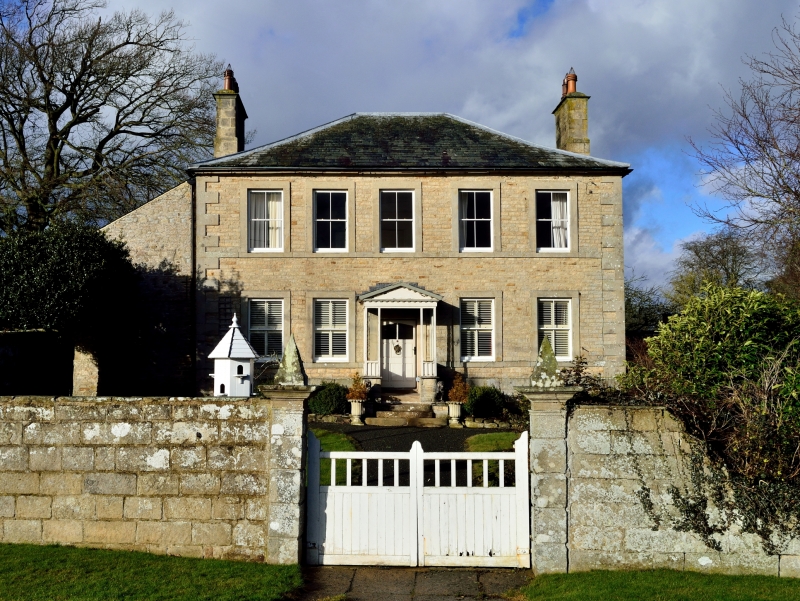
31/104 The Grove
GV II
House. Circa 1840 possibly incorporating C18 house. Squared sandstone rubble;
main block has graduated green slate roof, left section has Welsh slate roof;
stone chimney stacks.
2 storeys and basement, 5 bays, symmetrical. Raised quoins, low plinth, basement
and sill bands. 4 steps to central replaced door in C20 glazed, gabled porch.
Small basement windows are blocked to left and iron-barred to right. 4 -pane
sashes (some with intermediate glazing bars removed, some replaced) in projecting
surrounds. Coved eaves. Low-pitched, slightly-swept hipped roof. Stepped and
corniced lateral stacks.
2-storey section on left return, possibly part of an earlier house, has altered
openings and a monopitch roof. Rear of main block has scattered 12-pane sashes.
Interior: dogleg staircase, of 2 flights plus landing rail, has knopped turned
balusters and ramped handrail.
Listing NGR: NZ0148417709
External links are from the relevant listing authority and, where applicable, Wikidata. Wikidata IDs may be related buildings as well as this specific building. If you want to add or update a link, you will need to do so by editing the Wikidata entry.


Other nearby listed buildings
