Approximate Location Map
Large Map »
Latitude: 52.3104 / 52°18'37"N
Longitude: 0.3913 / 0°23'28"E
OS Eastings: 563115
OS Northings: 270723
OS Grid: TL631707
Mapcode National: GBR N94.3RR
Mapcode Global: VHJG9.Q6Q6
Plus Code: 9F42896R+5G
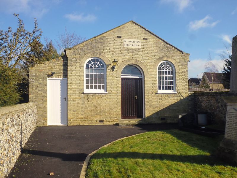
Entry Name: Chapel Hall
Listing Date: 31 January 1984
Grade: II
Source: Historic England
Source ID: 1126351
English Heritage Legacy ID: 49036
ID on this website: 101126351
Location: Fordham, East Cambridgeshire, CB7
County: Cambridgeshire
District: East Cambridgeshire
Civil Parish: Fordham
Built-Up Area: Fordham
Traditional County: Cambridgeshire
Lieutenancy Area (Ceremonial County): Cambridgeshire
Church of England Parish: Fordham St Peter and St Mary Magdalene
Church of England Diocese: Ely
Tagged with: Chapel
TL 6370 FORDHAM MILL LANE
(east side)
12/110 Chapel Hall
GV II
Chapel Hall formerly the Sunday School, plaque with date of
erection, 1844. Gault brick, low pitch slate roof, coped gable
facing west. Central double, boarded doors flanked by two hung
sash windows shaped to round headed brick arches.
Listing NGR: TL6311570723
External links are from the relevant listing authority and, where applicable, Wikidata. Wikidata IDs may be related buildings as well as this specific building. If you want to add or update a link, you will need to do so by editing the Wikidata entry.


Other nearby listed buildings
