Approximate Location Map
Large Map »
Latitude: 52.3993 / 52°23'57"N
Longitude: 0.2638 / 0°15'49"E
OS Eastings: 554112
OS Northings: 280332
OS Grid: TL541803
Mapcode National: GBR M6H.FJ9
Mapcode Global: VHHJ6.JY9K
Plus Code: 9F4297X7+PG
Entry Name: Nos. 20, 22, 24 and 24A High Street
Listing Date: 23 September 1950
Last Amended: 18 November 2016
Grade: II
Source: Historic England
Source ID: 1126485
English Heritage Legacy ID: 48744
ID on this website: 101126485
Location: Ely, East Cambridgeshire, CB7
County: Cambridgeshire
District: East Cambridgeshire
Civil Parish: Ely
Built-Up Area: Ely
Traditional County: Cambridgeshire
Lieutenancy Area (Ceremonial County): Cambridgeshire
Church of England Parish: Ely
Church of England Diocese: Ely
Tagged with: Building
A row of four former timber-framed buildings, now three shops, built in the C16, probably as shops with domestic accommodation, with C18, C19, C20 and early-C21 alterations and additions. Stone walling incorporated into the rear of Nos. 22 and 24 has been interpreted as the north wall of a mid-C14 charnel house.
A row of four former timber-framed buildings, built in the C16 as shops with domestic accommodation, with C18, C19, C20 and early-C21 alterations and additions. Stone walling to the rear of Nos. 22 and 24 has been interpreted as the north wall of a mid-C14 charnel house.
MATERIALS: of brick (Nos.20-24 are plastered) with tiled roofs and brick stacks. The rear wall to Nos.22 and 24 is comprised of mid-C14 coursed stone rubble, now painted.
PLAN: the four buildings form an irregular row, aligned east to west, on the south side of the High Street. Each was originally of a single room depth, but all have now been enlarged at the rear with a range of single- and two-storey additions related to commercial use.
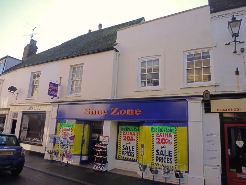
EXTERIOR: Nos. 20 to 24A High Street comprise an irregular row of four buildings which have now been consolidated as three shop units. All are of two storeys, with No.20 set back from the building line of the other three buildings, while No.24A has a lower ridge line than that of Nos.22 and 24. Nos.20 to 24 are rendered with plaster whilst No.24A is of painted brick.
From right to left, No.20 has a deep parapet, a vestigial reminder of it once being a three-storey building, with a flat roof behind. On the first floor there are two six-over-six sashes, in flush cased frames, with moulded architraves of which that to the right-hand side window partly extends into the façade of No.18. Running beneath the windows is a moulded platband. To the ground floor there is a late-C20 shopfront which also extends across the ground floor of No.22. It has a panelled stall riser, plate glass windows and a deep facia set between the consoles of fluted pilasters. A fluted central post marks the original division between Nos.20 and 22. To the first floor of No.22 there is a six-over-six sash with stone lintels and plain reveals, now plastered. To the left, No.24 has an early-C21 shopfront with a plate glass window set between plain pilasters supporting a shallow fascia. A six-panelled door sits to the left-hand side of the shop window. Above, the first-floor has an identical sash to that at No.22. Both Nos.22 and 24 have a dentilled cornice, partially hidden by a late-C20 uPVC gutter, and late-C20/early-C21 hanging shop signs. Tile work patches in the roof of these two buildings indicate the former positions of C19 dormers. To the left again, No.24A has a late-C19 shopfront to the ground floor with a two-light shop window and recessed entrance set between plain, narrow pilasters with plain capitals. Over is a shallow fascia. To the first floor there is a late-C19 canted oriel of 1:1:1-lights and to the attic there is a C20 dormer with a three-light casement. Partially hidden by a late-C20 uPVC gutter is a cogged eaves cornice.
The rear wall of Nos.22 and 24 is formed by a two-storey section of mid-C14 stone walling, it being the surviving north wall of a former charnel house associated with the medieval parish cemetery which lay immediately to the south. It has a large, blocked, arched window opening, with a simple chamfer moulding and straight-sided jambs, sitting on the boundary of the two buildings at first floor level. To the right-hand side of the window is a jagged section of stonework which probably indicates the position of the return (east) wall of the charnel house. Projecting from No.24 is a smaller, two-storey, brick-built extension of C18 date, which was extended in the C19 to encompass No.22, probably when both buildings were jointly used as a tea room. Nos.22 and 24 both have C20 extensions, being of two-storeys and a single-storey respectively. To the right-hand side, No.24A has a two-storey, cross-wing addition of C18 date, with a mono-pitch roof. Its ground-floor is painted, and is largely of brick, but with some stone, perhaps reused from the earlier monastic boundary wall. At first-floor level there is a large, C20, canted oriel of 1:2:1-lights.
INTERIOR: the ground floors of Nos.20 and 22 comprise a single shop unit with a late-C20 suspended ceiling concealing any evidence of an earlier ceiling structure. At the rear a small section of mid-C14 walling is visible. The first-floor rooms have been opened out for storage, but their height and proportions suggest that they date from a C18 remodelling, with a roughly finished timber ceiling beam built out on a brick corbel believed to be of this date. A probable C16 cross beam is partly concealed in the party wall with No.18.
The ground floor on No.24 largely contains late-C20 fixtures and fittings relating to its current use as a butchers shop. Above, its first floor, which has now been amalgamated with that of No.24A, has a high ceiling, again probably representative of a C18 remodelling. Two window spays are visible on the front (north) wall, one either side of the current C19 sash, and probably represent a single earlier window, or two narrow window openings, possibly of C18 date. They have both been retained as recesses and fitted out with shelves. The rear (south) wall incorporates the chimney breast, with the outline of the former fireplace visible in the centre. On its west side is a small cupboard recess. Running through the centre of the room is a cased cross beam.
The first floor of No.24A, again with high ceilings suggestive of a C18 date, is subdivided by C20 stud partition walls into two rooms with a small lobby area at the top of a winder staircase. Originally of a single room, two C16 cross beams are visible in the party walls while a C16 lateral beam runs across the width of the building, originally dividing the C16 room in two. All three beams are chamfered with diagonal step stops. Where the cross beams meet the front (north) wall they have residual mortises partly visible indicating the former position of jowled posts. The cut back remains of the lap-dovetail joint that would have connected the beam to a wall plate is also visible. Both cross beams have secondary timbers attached to their sides, possibly added for reinforcement in the C18, when the timber-framed north façade was replaced with brick. A doorway in the stud partition wall between Nos.24 and 24A allows access between two buildings at this level. The stud wall has a wider plinth level which rises to a height of about 0.8m. As this is out of alignment with the stud wall above, sitting directly underneath the cross beam next to the partition, it probably indicates that the plinth is part of an earlier dividing wall between the two buildings. To the south of the current doorway, an earlier blocked doorway is visible in the partition wall in the stairwell. To the ground-floor of No.24A, the winder staircase to the first-floor is now blocked, but is believed to be of stone construction. A blocked, wide and slightly arched opening in the east wall of No.24 indicates that Nos.24 and 24 A were once opened up to each other. The attic of No.24A has a C19 sling-brace truss sitting roughly centrally with the room. Its base support sits on top of the exposed timber floorboards, and is fixed with nails to an earlier ceiling joist which runs out underneath them. The truss comprises an interrupted tie beam which runs out from the wall plate and is tenoned into the sling brace. The brace itself rises into the plaster ceiling so its relationship with any possible collar cannot be seen.
Pursuant to s.1 (5A) of the Planning (Listed Buildings and Conservation Areas) Act 1990 (‘the Act’) it is declared that the late-C20 suspended ceiling to the ground floor of Nos.20 and 22 is not of special architectural or historic interest.
The present city of Ely rises 20m above the surrounding fen on an island of Kimmeridge clay. Although well connected by river and waterways, until the C17 only causeways connected the island to the mainland, and in the early years of Christianity its isolation made it an ideal refuge for those seeking a secluded monastic life. The first successful attempt to establish a religious settlement here was made by Etheldreda in c.673, re-endowed by King Edgar 100 years after its destruction by the Danes in 870. Despite threats of further invasion in the C11, and later political turmoil, this monastery survived until its dissolution in 1539. The presence of a monastic community occupying substantial buildings required the support of a lay community, and as that grew, so did the needs of the lay-people for accommodation and services. A detailed survey of 1416 recorded 457 buildings and described an established street pattern; by 1563 the number of households had grown to 800. Despite this growth in population, John Speed’s map of Ely, published in 1611/12, is very similar in both layout and extent to that of the first edition Ordnance Survey (OS) Map of 1885, where the only significant expansion is towards the railway (1845): however, in Speed’s map, houses lining the streets enclose spaces of apparently horticultural and even agricultural production, and while these are still present on the 1885 map they have been pushed to the margins of the city. These maps graphically illustrate the continuing importance of agriculture and agriculturally related industries in the early C17 and beyond, and also show that the later growth in population took place mainly within the confines of the early city street plan. Before the later C19, the only significant rival to agriculture was the pottery industry, in production from the C12 to 1860.
Following the dissolution of the monastery, Ely remained the centre of the diocese, but the loss of the community, and of pilgrims to the shrine of St Etheldreda, would have had a considerable impact on the city’s economy. The consequent decline in management of the fen and its waterways led to an increase in flooding, and attempts at drainage in the C17 and C18 seem to have had limited effect, creating constraints on the ability of the city to thrive. Successive literary travellers commented on the poor drainage, including Celia Fiennes in the mid-C17, who described the city as a “perfect quagmire”, and Daniel Defoe in the early C18, who noted both the city’s market gardens and its overflowing wells. By the mid-C19 the city was in a state of recovery and regeneration: several possible contributory factors include successful drainage, enclosure (1848) and the arrival of the railway with the opening of the Cambridge to Ely line in 1845. This was followed slightly later by other lines, making the city a transport hub. Despite this, the physical expansion of Ely beyond its medieval core was slow through the mid-C20, accelerating through the late C20 and into the C21, as Ely developed as a dormitory town for Cambridge.
Nos.20 to 24A High Street, a row of four buildings, form part of an irregular row of buildings which run almost continuously along the south side of the street, from the Almonry (Grade I) in the east to its junction with Minster Place in the west. Along with the highway to the north, which was known as Stepilrowe (Steeple Row) during the medieval period, the narrow strip of land on which the four buildings stand is bounded to the south by the former monastic precinct. In around 1359, the parish church of Holy Cross, later Holy Trinity, was built against the north wall of the cathedral's nave, with a burial ground laid out on land between the north side of the church and the north boundary wall of the monastic precinct; the latter being roughly aligned with the rear walls of the buildings that now stand on the south side of the High Street. Contemporary with the church and cemetery was a charnel house whose north façade was set within the line of the north boundary wall. Documentary evidence states that it was a two-storey structure with a chapel dedicated to St Peter on the first floor. Although now largely demolished, at an unknown date, its north wall still stands, incorporated into the rear walls of Nos.22 and 24 High Street. By the early C15, documented in a rental survey of 1416/17, the narrow strip of land between the monastic precinct boundary and Steeple Row had been developed with a row of tenements. Owned by the Prior of the Abbey or the Bishop, it is likely that they were built to exploit the commercial potential of the area. The tenements were completely rebuilt in the C16, probably as shops with domestic accommodation, with the surviving structural fabric in No.24A suggesting that they were timber-framed. During the C18, Nos.20 to 24A were re-fronted in brick, with No.24 also being extended at the rear. More substantial alterations took place in the C19, with the installation of new shop fronts to each building, while Nos.20 to 24 were rendered with plaster and had double-hung sashes installed. No.24A was also fitted with a first-floor canted oriel and a large dormer along with a two-storey cross-wing at the rear. An early-C20 photograph of the four buildings, taken between 1905 and 1910, shows that No.20, then occupied by a newsagent, was of three storeys, while Nos.22 and 24 were in single occupancy as a tea room. Blocked internal doorways in the party wall between Nos.24 and 24A also provides evidence for these two buildings being in single use/occupancy at one time, but it is not known when this took place. During the C20, the upper storey to No.20 was removed, leaving a deep parapet, and the dormers to Nos.22 and 24 were removed while that to No.24A was enlarged. All the buildings underwent internal reordering in the second half of the C20, with the results now being that Nos.20 and 22 form a single shop unit (Shoe Zone); No.24 comprises a single butchers shop to the ground floor (Edis of Ely) with its upper floor amalgamated with that of No.24A, the latter with a single shop unit (Curtis Yarns) at ground-floor level.
Nos.20 to 24A High Street, a row of four former timber-framed buildings of C16 date, incorporating fabric from a mid-C14 charnel house to the rear of Nos.22 and 24, with C18, C19, C20 and early-C21 alterations and additions, are listed at Grade II for the following principal reasons:
* Architectural interest: they have evolved over six centuries, reflecting the changing needs of succeeding occupants and retaining fabric and structural detail from each phase, thus providing important evidence of historic building traditions;
* Historic interest: they lie within the area of settlement depicted on John Speed’s map of 1610/1611, a street pattern established by the early C15, and make an important contribution to the historical development of the townscape;
* Group value: they form a strong group with all the listed buildings on the High Street, particularly Steeple Gate (Grade II*) which adjoins No.20.
External links are from the relevant listing authority and, where applicable, Wikidata. Wikidata IDs may be related buildings as well as this specific building. If you want to add or update a link, you will need to do so by editing the Wikidata entry.


Other nearby listed buildings
