Approximate Location Map
Large Map »
Latitude: 50.3832 / 50°22'59"N
Longitude: -4.0274 / 4°1'38"W
OS Eastings: 255956
OS Northings: 55665
OS Grid: SX559556
Mapcode National: GBR Q2.09BN
Mapcode Global: FRA 28G1.0SQ
Plus Code: 9C2Q9XMF+72
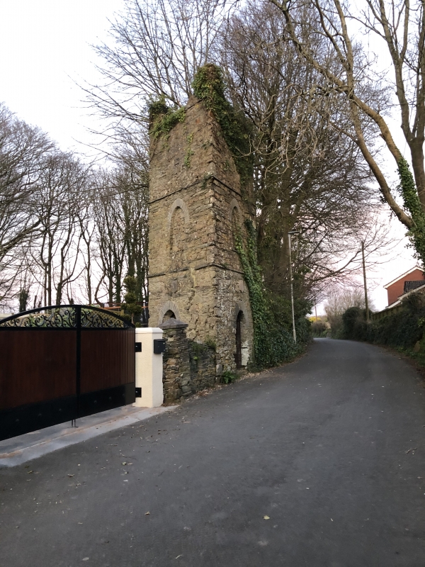
Entry Name: Triangular Folly
Listing Date: 9 November 1998
Grade: II
Source: Historic England
Source ID: 1130046
English Heritage Legacy ID: 473283
ID on this website: 101130046
Location: Chaddlewood, Plymouth, Devon, PL7
County: City of Plymouth
Electoral Ward/Division: Plympton Chaddlewood
Parish: Non Civil Parish
Built-Up Area: Plymouth
Traditional County: Devon
Lieutenancy Area (Ceremonial County): Devon
Tagged with: Building
SX 5555
740-1/51/425
PLYMOUTH
CORNWOOD ROAD, Plympton
Triangular Folly
II
Folly. Probably late C18. Slatestone rubble walls with slate
string courses and parapet with corner merlons. Simple Gothic
style. Triangular plan with entrances to 2 sides. 3 stages;
pointed arched doorways to lower stage and blind pointed
arches to stage above.
Listing NGR: SX5595655665
External links are from the relevant listing authority and, where applicable, Wikidata. Wikidata IDs may be related buildings as well as this specific building. If you want to add or update a link, you will need to do so by editing the Wikidata entry.


Other nearby listed buildings
