Approximate Location Map
Large Map »
Latitude: 52.4477 / 52°26'51"N
Longitude: -0.1096 / 0°6'34"W
OS Eastings: 528569
OS Northings: 284987
OS Grid: TL285849
Mapcode National: GBR K2R.H2Y
Mapcode Global: VHGLC.1QWY
Plus Code: 9C4XCVXR+34
Entry Name: 29, High Street
Listing Date: 8 June 1983
Grade: II
Source: Historic England
Source ID: 1130229
English Heritage Legacy ID: 54457
ID on this website: 101130229
Location: Ramsey, Huntingdonshire, Cambridgeshire, PE26
County: Cambridgeshire
District: Huntingdonshire
Civil Parish: Ramsey
Built-Up Area: Ramsey
Traditional County: Huntingdonshire
Lieutenancy Area (Ceremonial County): Cambridgeshire
Church of England Parish: Ramsey St Thomas a Becket
Church of England Diocese: Ely
Tagged with: Building
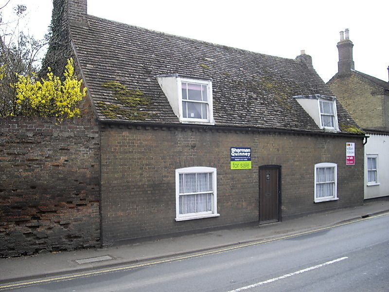
TL 2885-2985 RAMSEY HIGH STREET
13/2 (south side)
No 29
GV
II
Medieval timber-framed cottage, 2 unit plan altered in C17 and early C19. Now cased
in gault brick. Plain tile roof, end stacks. Two flat roofed dormer windows with
hung sashes. Central door and 2 hung sash windows in segmental arches.
Listing NGR: TL2856984987
External links are from the relevant listing authority and, where applicable, Wikidata. Wikidata IDs may be related buildings as well as this specific building. If you want to add or update a link, you will need to do so by editing the Wikidata entry.


Other nearby listed buildings
