Approximate Location Map
Large Map »
Latitude: 54.7148 / 54°42'53"N
Longitude: -3.5004 / 3°30'1"W
OS Eastings: 303441
OS Northings: 536570
OS Grid: NY034365
Mapcode National: GBR 3FZX.ZN
Mapcode Global: WH5YB.6RDD
Plus Code: 9C6RPF7X+WR
Entry Name: 8 Senhouse Street
Listing Date: 27 May 1977
Grade: II
Source: Historic England
Source ID: 1137674
English Heritage Legacy ID: 71855
ID on this website: 101137674
Location: Maryport, Cumberland, Cumbria, CA15
County: Cumbria
District: Allerdale
Civil Parish: Maryport
Built-Up Area: Maryport
Traditional County: Cumberland
Lieutenancy Area (Ceremonial County): Cumbria
Church of England Parish: Maryport St Mary with Christ Church
Church of England Diocese: Carlisle
Tagged with: Building
This list entry was subject to a Minor Enhancement on 20 July 2022 to amend the description and to reformat the text to current standards.
NY 0336
1/97
MARYPORT
SENHOUSE STREET (north side)
No 8
GV
II
Maryport is a mid-C18 Cumbrian town and port, succeeding a small settlement and harbour known as Ellenfoot (Alnfoot), established on a planned grid pattern by Humphrey Senhouse (1731-1814) to serve the local coal mining and iron industry, and function as a minor shipping point. The town officially became known as Maryport in 1756 after Humphrey Senhouse’s wife, although it had unofficially been referred to as such since the 1750s. During the C19 the town and port expanded to serve the local iron and steel industries as the town’s shipbuilding industry developed, and by the mid-C19 coal exporting had declined and the railway was introduced. The port and town remained important on the west Cumberland coast, but declined with the cessation of major industrial activity from the late 1920s. Maryport has been known as a destination for sea bathing since the late C18.
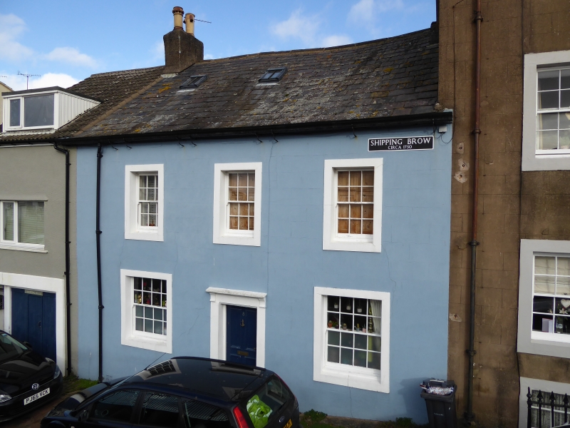
Senhouse Street, running from Curzon Street to the harbour, retains its historic layout of diverse and varied C18 and C19 buildings. Its north-west end is known as Shipping Brow and forms the earliest part of the mid-C18 grid pattern. It is labelled as the town’s earliest marketplace, known as Old Market Brow, in a map of around 1756, and as a consequence is wider than other streets in the town with continuous rows of houses north and south (now with a handful of buildings removed). By the early C19 it was no longer the official marketplace, but remained a prominent residential and commercial area, with those involved in the town’s principal industries residing there. A 1955 painting by L S Lowry depicts this building with the suggestion of a rendered blue elevation.
Rendered two-storey C18 house with stone window surrounds, with chamfered reveals, beneath a stone slate roof. It has two ground-floor windows either side of an entrance doorway containing a C19 four-panel door with a small cornice above supported on brackets. The first floor has three windows.
Listing NGR: NY0344136570
External links are from the relevant listing authority and, where applicable, Wikidata. Wikidata IDs may be related buildings as well as this specific building. If you want to add or update a link, you will need to do so by editing the Wikidata entry.


Other nearby listed buildings
