Approximate Location Map
Large Map »
Latitude: 54.6629 / 54°39'46"N
Longitude: -3.3618 / 3°21'42"W
OS Eastings: 312255
OS Northings: 530612
OS Grid: NY122306
Mapcode National: GBR 4GYJ.Z7
Mapcode Global: WH6ZX.B2C4
Plus Code: 9C6RMJ7Q+57
Entry Name: Former Mill
Listing Date: 26 July 1974
Grade: II
Source: Historic England
Source ID: 1144734
English Heritage Legacy ID: 71668
ID on this website: 101144734
Location: Cockermouth, Cumberland, Cumbria, CA13
County: Cumbria
District: Allerdale
Civil Parish: Cockermouth
Built-Up Area: Cockermouth
Traditional County: Cumberland
Lieutenancy Area (Ceremonial County): Cumbria
Church of England Parish: Cockermouth Area Team
Church of England Diocese: Carlisle
Tagged with: Mill
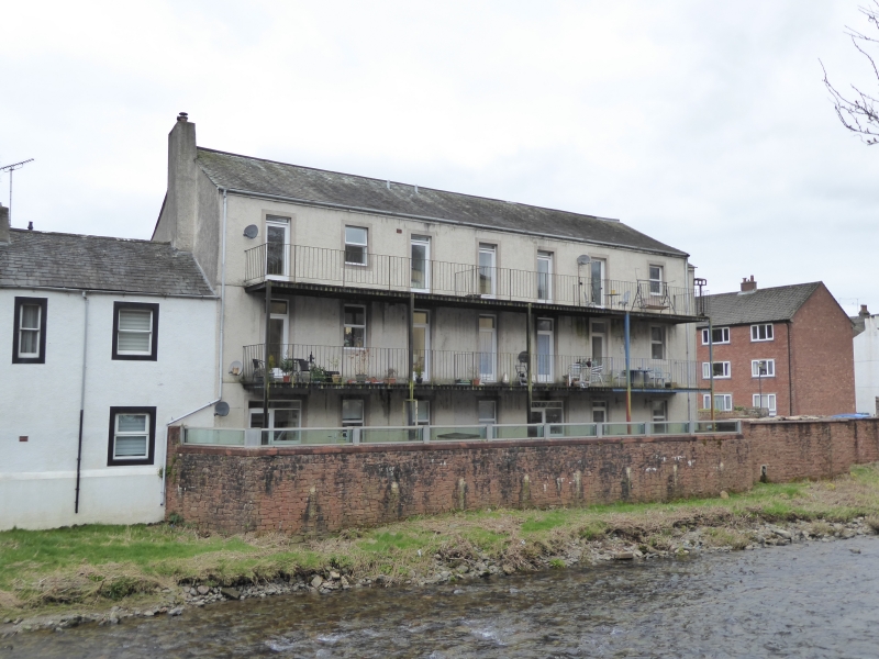
1.
5161 THE CROFT
Former mill
NY 1230 1/20
II GV
2.
Now a warehouse. Early C19. Pebble-dashed. Stone rubble, slate roof, 3 storeys.
7 modern windows on each floor, and new doors. Rear to river stone rubble, with
doors to balconies on each floor.
Nos 1 to 4 (consec) and the former mill form a group.
Listing NGR: NY1225530612
External links are from the relevant listing authority and, where applicable, Wikidata. Wikidata IDs may be related buildings as well as this specific building. If you want to add or update a link, you will need to do so by editing the Wikidata entry.


Other nearby listed buildings
