Approximate Location Map
Large Map »
Latitude: 54.1434 / 54°8'36"N
Longitude: -2.7701 / 2°46'12"W
OS Eastings: 349789
OS Northings: 472226
OS Grid: SD497722
Mapcode National: GBR 9N3J.2G
Mapcode Global: WH83V.F34X
Plus Code: 9C6V46VH+9X
Entry Name: Warton Hall Farmhouse
Listing Date: 2 May 1968
Grade: II
Source: Historic England
Source ID: 1146601
English Heritage Legacy ID: 182015
ID on this website: 101146601
Location: Warton, Lancaster, Lancashire, LA5
County: Lancashire
District: Lancaster
Civil Parish: Warton
Built-Up Area: Warton
Traditional County: Lancashire
Lieutenancy Area (Ceremonial County): Lancashire
Church of England Parish: Warton St Oswald (or Holy Trinity)
Church of England Diocese: Blackburn
Tagged with: Farmhouse
SD 47 SE WARTON MAIN STREET (NORTH SIDE)
3/247 No. 57 (Warton Hall Farmhouse)
2. 5. 1968
II
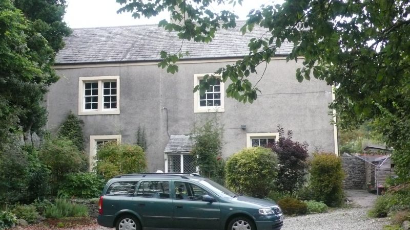
House, possibly late C18th. Pebbledashed rubble with slate roof. Central
porch of limestone and timber, probably late C19th, over doorway with plain
dressed limestone surround. To each side of this is a sashed window with
glazing bars and plain stone surround. At the far left is a blocked door
with plain stone surround, now a fixed window with glazing bars. On the
1st floor to the left is a plain stone surround with a square stone mullion
separating 2 sashed windows with glazing bars. To the right is a sashed
window with glazing bars in a plain stone surround. Chimneys to the left of
the door and on the right-hand gable. Right-hand gable has sashed window
with glazing bars and plain reveals on the 1st floor. Outshut at rear with
horizontal sliding sash with glazing bars, plain reveals and segmental head.
On the 1st floor is a 2-light rebated and chamfered mullioned window.
Listing NGR: SD4978972226
External links are from the relevant listing authority and, where applicable, Wikidata. Wikidata IDs may be related buildings as well as this specific building. If you want to add or update a link, you will need to do so by editing the Wikidata entry.


Other nearby listed buildings
