Approximate Location Map
Large Map »
Latitude: 51.9457 / 51°56'44"N
Longitude: -0.4438 / 0°26'37"W
OS Eastings: 507060
OS Northings: 228605
OS Grid: TL070286
Mapcode National: GBR G4B.W2F
Mapcode Global: VHFR7.8C79
Plus Code: 9C3XWHW4+7F
Entry Name: Streatley House
Listing Date: 3 February 1967
Last Amended: 26 September 1980
Grade: II
Source: Historic England
Source ID: 1159228
English Heritage Legacy ID: 36077
ID on this website: 101159228
Location: Streatley, Central Bedfordshire, LU3
County: Central Bedfordshire
Civil Parish: Streatley
Built-Up Area: Streatley
Traditional County: Bedfordshire
Lieutenancy Area (Ceremonial County): Bedfordshire
Church of England Parish: Streatley
Church of England Diocese: St.Albans
Tagged with: House
1.
5125 STREATHLEY SHARPENHOE ROA
(west side)
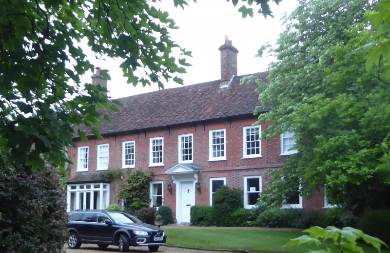
Streatley House
TL 02 NE 23/277 3.2.67
II
2.
C18. Chequered, brick. Two storeys. Old clay tile roof. Nine sashes, no glazing
bare to ground floor. Left hand C19 one storey hipped roofed bay window. Six
fielded panel door in architrave. Cut bracketed pedimented doorhood.
Listing NGR: TL0706028605
External links are from the relevant listing authority and, where applicable, Wikidata. Wikidata IDs may be related buildings as well as this specific building. If you want to add or update a link, you will need to do so by editing the Wikidata entry.


Other nearby listed buildings
