Approximate Location Map
Large Map »
Latitude: 52.2385 / 52°14'18"N
Longitude: 0.0196 / 0°1'10"E
OS Eastings: 537999
OS Northings: 261957
OS Grid: TL379619
Mapcode National: GBR K5F.RR9
Mapcode Global: VHHJV.9Z6V
Plus Code: 9F4262Q9+CR
Entry Name: Church of St Peter and St Paul
Listing Date: 31 August 1962
Grade: II*
Source: Historic England
Source ID: 1162717
English Heritage Legacy ID: 51703
ID on this website: 101162717
Location: St Peter and St Paul's Church, Dry Drayton, South Cambridgeshire, CB23
County: Cambridgeshire
District: South Cambridgeshire
Civil Parish: Dry Drayton
Built-Up Area: Dry Drayton
Traditional County: Cambridgeshire
Lieutenancy Area (Ceremonial County): Cambridgeshire
Church of England Parish: Dry Drayton St Peter and St Paul
Church of England Diocese: Ely
Tagged with: Church building
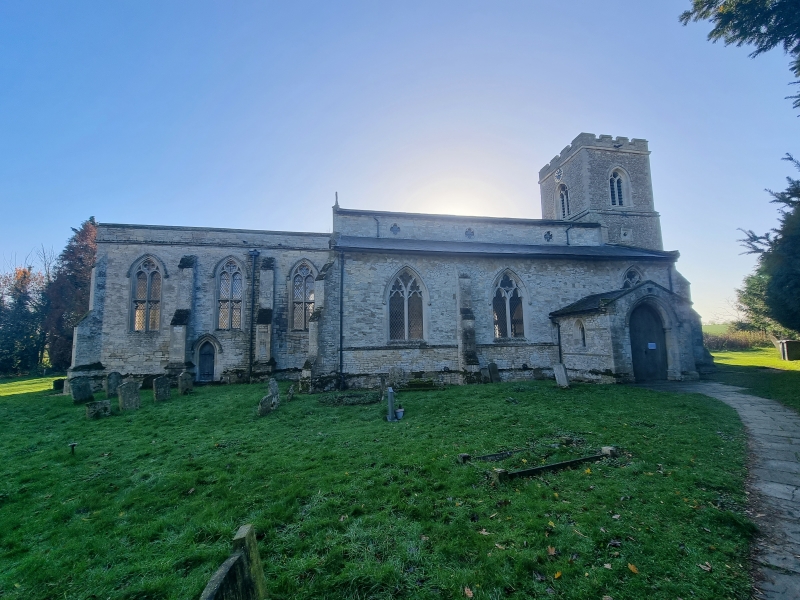
TL 36 SE DRY DRAYTON PARK STREET
(South Side)
1/86 Church of St Peter
31. 8.62 and St Paul
II*
Parish Church. Late C13 West tower, late C13 and C14 nave arcades,
substantial C19 restorations including the rebuilding of the chancel in 1851
and the west tower restoration of 1874. Pebble and fieldstones with clunch
dressings to windows and doors and limestone to quoins. Original wall
material cased with broken pieces of limestone ashlar and the clunch
dressings have mostly been replaced by Ketton stone. Slate roofs. West
tower of three stages, with C19 brick embattlement and two-light bell stage
openings and west window. Nave has C19 clerestorey with three C14 style
quatrefoil openings. South aisle also restored late C13 or early C14 work.
Chancel C19. Interior: North and south nave arcades of three bays, each
with two-centred arches of two chamfered orders on octagonal columns with
moulded capitals but obscured bases. Both sides of north arcade have moulded
labels with mask stops. Tower arch of three chamfered arches, the inner of
half-octagonal responds with moulded capital and bases. The chancel arch is
similar to that of the nave arcade. Font: C13 limestone. Octagonal basin
on square stem with polygonal shafts to each side. Brasses: West of chancel
arch. Thomas Hatton and his wife 1540. Male and female figures with shields
of arms above and indents for two groups of children and inscription. In
chancel; male figure with inscription plate. Medieval.
R.C.H.M. West Cambs., mon.(1)
Pevsner. Buildings of England, p331
Listing NGR: TL3799961957
External links are from the relevant listing authority and, where applicable, Wikidata. Wikidata IDs may be related buildings as well as this specific building. If you want to add or update a link, you will need to do so by editing the Wikidata entry.


Other nearby listed buildings
