Approximate Location Map
Large Map »
Latitude: 51.211 / 51°12'39"N
Longitude: -2.3765 / 2°22'35"W
OS Eastings: 373799
OS Northings: 145826
OS Grid: ST737458
Mapcode National: GBR 0SM.001
Mapcode Global: VH97C.RTJH
Plus Code: 9C3V6J6F+CC
Entry Name: Fulwell House
Listing Date: 27 November 1984
Grade: II
Source: Historic England
Source ID: 1174607
English Heritage Legacy ID: 266809
ID on this website: 101174607
Location: Nunney, Somerset, BA11
County: Somerset
District: Mendip
Civil Parish: Nunney
Built-Up Area: Nunney
Traditional County: Somerset
Lieutenancy Area (Ceremonial County): Somerset
Tagged with: House
ST7345
12/111
NUNNEY CP
FROME ROAD (North side)
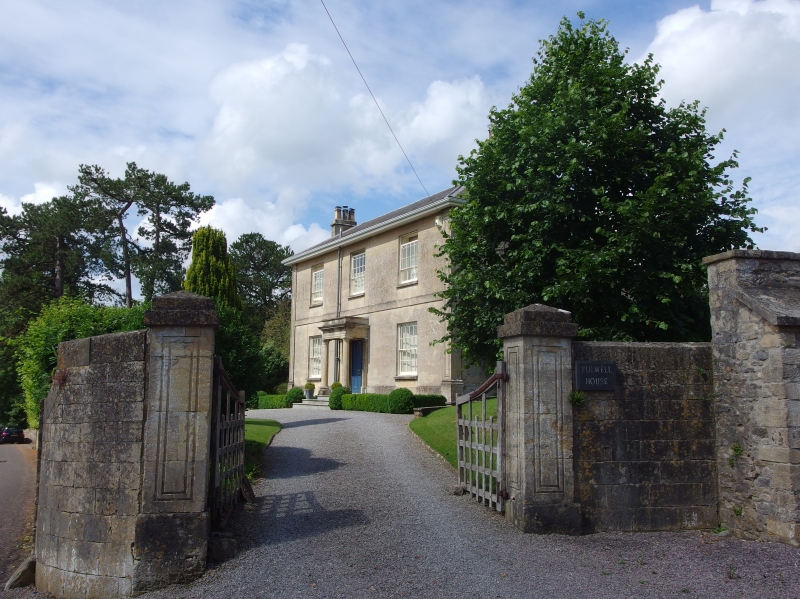
Fulwell House
GV
II
House. Early C19. Doulting ashlar, corner pilasters, plain stone band at first floor level, wide eaves, slate hipped
roof, ashlar stack to left side. Plain facade. 2-storeys, 3-bays, sash windows with glazing bars and marginal lights in
reveals. Central door opening, stone portico, flat entablature, pilasters to wall, 4-panelled door.
Listing NGR: ST7379945826
External links are from the relevant listing authority and, where applicable, Wikidata. Wikidata IDs may be related buildings as well as this specific building. If you want to add or update a link, you will need to do so by editing the Wikidata entry.


Other nearby listed buildings
