Approximate Location Map
Large Map »
Latitude: 51.1118 / 51°6'42"N
Longitude: -2.4534 / 2°27'12"W
OS Eastings: 368357
OS Northings: 134821
OS Grid: ST683348
Mapcode National: GBR MX.BB6T
Mapcode Global: VH8BG.FBB1
Plus Code: 9C3V4G6W+PJ
Entry Name: Bow Bridge
Listing Date: 24 March 1961
Grade: I
Source: Historic England
Source ID: 1176195
English Heritage Legacy ID: 261617
Also known as: The Packhorse Bridge 100m north west of the Church of St Mary
ID on this website: 101176195
Location: Bruton, Somerset, BA10
County: Somerset
District: South Somerset
Civil Parish: Bruton
Built-Up Area: Bruton
Traditional County: Somerset
Lieutenancy Area (Ceremonial County): Somerset
Tagged with: Footbridge Packhorse bridge
ST6834NW
8/144
BRUTON CP
PLOX (North West side)
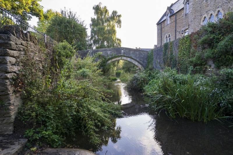
Bow Bridge (also known as The Packhorse Bridge)
24.3.61
GV I
Footbridge. Possibly C15. Local stone ashlar. Slightly pointed 2-order chamfered arch, with angled parapets and copings
making slight point in centre, with return walls along footpath to North. On West side is an eroded carved shield set
into the parapet, and on North West corner the remains of a plinthed pier. Walkway less than 1 metre wide, with Keinton
flags to South side and stone setts to North. Bridge has been several times damaged by flooding of the River Brue,
latest 1982/3, with subsequent repair. The shield thought to bear the dolphin of the Fitzpanes family, who lived at
Redlynch in the C15 and C16, and founded Kings School (qv), suggesting that they may have rebuilt this probable link
between the former Abbey, being opposite the supposed gatehouse of same, and its Court House in the High Street (Nos 34
and 36 qv). Scheduled Ancient Monument (Somerset County No 176). (Couzens P, Bruton in Selwood, Abbey Press, Sherborne,
1972).
Listing NGR: ST6835734821
External links are from the relevant listing authority and, where applicable, Wikidata. Wikidata IDs may be related buildings as well as this specific building. If you want to add or update a link, you will need to do so by editing the Wikidata entry.


Other nearby listed buildings
