Approximate Location Map
Large Map »
Latitude: 50.8705 / 50°52'13"N
Longitude: -0.3051 / 0°18'18"W
OS Eastings: 519357
OS Northings: 109254
OS Grid: TQ193092
Mapcode National: GBR HM0.7PP
Mapcode Global: FRA B67S.YT1
Plus Code: 9C2XVMCV+5X
Entry Name: Church of St Botolph
Listing Date: 15 March 1955
Grade: I
Source: Historic England
Source ID: 1191927
English Heritage Legacy ID: 298330
ID on this website: 101191927
Location: St Botolphs Church, Botolphs, Horsham, West Sussex, BN44
County: West Sussex
District: Horsham
Civil Parish: Bramber
Built-Up Area: Steyning
Traditional County: Sussex
Lieutenancy Area (Ceremonial County): West Sussex
Church of England Parish: Beeding St Peter and Bramber St Nicholas
Church of England Diocese: Chichester
Tagged with: Church building Anglo-Saxon architecture
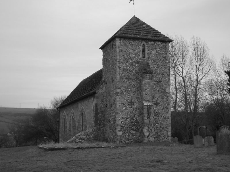
BRAMBER BOTOLPHS
1.
5404
Church of St Botolph
TQ 10 NE 15/50 15.3.55
I
2.
Chancel, nave, west tower and tiny south porch. Chancel arch and south wall
of nave Saxon. North wall of nave and blocked arches of former aisle C13.
Chancel and tower decorated. Porch C19. Horsham slab roof.
Listing NGR: TQ1935509256
External links are from the relevant listing authority and, where applicable, Wikidata. Wikidata IDs may be related buildings as well as this specific building. If you want to add or update a link, you will need to do so by editing the Wikidata entry.


Other nearby listed buildings
