Approximate Location Map
Large Map »
Latitude: 51.2111 / 51°12'40"N
Longitude: -3.4787 / 3°28'43"W
OS Eastings: 296808
OS Northings: 146809
OS Grid: SS968468
Mapcode National: GBR LJ.3VZR
Mapcode Global: VH5JY.NTBF
Plus Code: 9C3R6G6C+FG
Entry Name: Shute Farmhouse
Listing Date: 28 October 1976
Grade: II
Source: Historic England
Source ID: 1207889
English Heritage Legacy ID: 391231
ID on this website: 101207889
Location: Higher Town, Somerset, TA24
County: Somerset
District: Somerset West and Taunton
Civil Parish: Minehead
Built-Up Area: Minehead
Traditional County: Somerset
Lieutenancy Area (Ceremonial County): Somerset
Tagged with: Farmhouse
MINEHEAD
SS9646 ST MICHAEL'S ROAD
900-1/3/76 (North side)
28/10/76 Shute Farmhouse
II
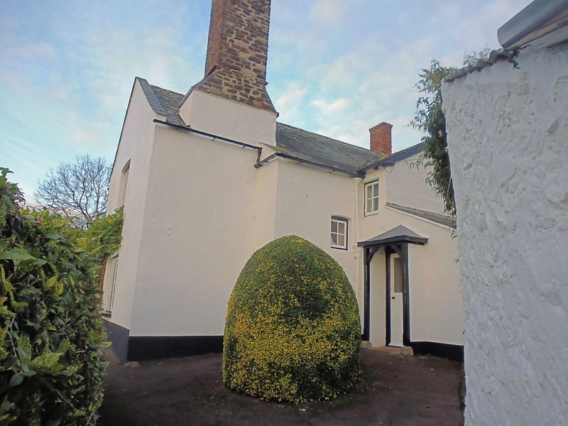
Farmhouse, now a house. C18 remodelling and alteration of
earlier house with C19 extension. Painted render over
rubblestone; slate and pantile roof, rubblestone stack to rear
right and left gable end, brick stack to left-of-centre.
Probably 3-unit through-passage plan later divided into 2
dwellings, now with a C19 double-gabled rear wing to the rear
left and lean-to to the right; now one house.
2 storeys; 4-window range. Mostly C19 two-light casement
windows with small panes. The pantiled left end of the house,
built into the hillside, has 2 half-dormers and a door to the
left. The slate-roofed right end has a C19 gabled porch
flanked by a 2-light window to the right and 3-light window to
the left.
INTERIOR: altered, but photographs of a former open fire and
bread oven under a central rear lateral stack exist.
HISTORY: The name probably means that it was a farm developed
on a block of strips or shot, at the end of one of the open
fields. This may mean that it originated in the 1400s when
demesne land was let for a money-rent and could by held in a
block with other strips.
(Binding H: Minehead: A New History: Minehead: 1977-: 202).
Listing NGR: SS9680846809
External links are from the relevant listing authority and, where applicable, Wikidata. Wikidata IDs may be related buildings as well as this specific building. If you want to add or update a link, you will need to do so by editing the Wikidata entry.


Other nearby listed buildings
