Approximate Location Map
Large Map »
Latitude: 53.4751 / 53°28'30"N
Longitude: -2.2433 / 2°14'35"W
OS Eastings: 383949
OS Northings: 397620
OS Grid: SJ839976
Mapcode National: GBR DJK.Y8
Mapcode Global: WHB9G.HXZB
Plus Code: 9C5VFQG4+2M
Entry Name: Lee House
Listing Date: 17 November 1987
Grade: II
Source: Historic England
Source ID: 1218358
English Heritage Legacy ID: 388156
ID on this website: 101218358
Location: Manchester, Greater Manchester, M1
County: Manchester
Electoral Ward/Division: City Centre
Parish: Non Civil Parish
Built-Up Area: Manchester
Traditional County: Lancashire
Lieutenancy Area (Ceremonial County): Greater Manchester
Church of England Parish: Manchester St Ann
Church of England Diocese: Manchester
Tagged with: Building
MANCHESTER
SJ8397NE GREAT BRIDGEWATER STREET
698-1/31/149 (South side)
17/11/87 No.90
Lee House
GV II
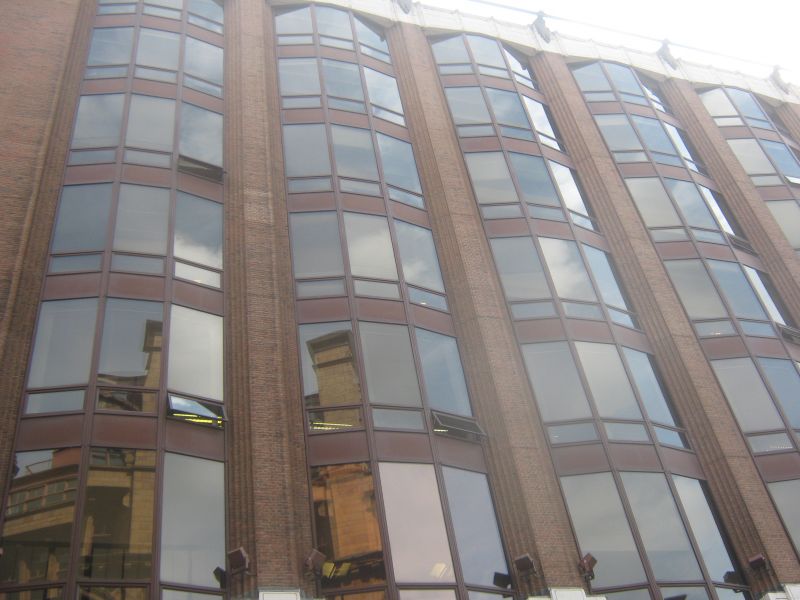
Warehouse, forming extension to Tootal, Broadhurst and Lee
building (56 Oxford Street, q.v.). 1928-31, by Harry S.
Fairhurst and Son; uncompleted. Steel frame clad in brown
brick with bronze-framed windows and some Portland stone
dressings (roof not visible). Rectangular plan. International
style. Eight storeys over basement, 6 bays to Bridgewater
Street, with broad corner pilasters and narrow chamfered piers
all of brick, vertically continuous canted 3-light
fenestration with bronze panels between the floors; except in
the 6th bay, which has square windows and brick ribbed panels;
and the basement-to-1st-floor levels of the first 2 bays
(containing a rectangular loading bay), the 4th bay (a doorway
and a window above this) and the 6th (1 window to each floor)
which are faced in Portland stone with Art Deco ornament.
Portland stone capping slightly arched over each bay, with a
metal rail attached by brackets and carried round. Right-hand
return and rear similar. History: was designed to rise to 217
feet with 17 storeys, completion prevented presumably by the
Great Depression of 1929-31.
Listing NGR: SJ8394997620
External links are from the relevant listing authority and, where applicable, Wikidata. Wikidata IDs may be related buildings as well as this specific building. If you want to add or update a link, you will need to do so by editing the Wikidata entry.


Other nearby listed buildings
