Approximate Location Map
Large Map »
Latitude: 54.256 / 54°15'21"N
Longitude: -2.9902 / 2°59'24"W
OS Eastings: 335586
OS Northings: 484938
OS Grid: SD355849
Mapcode National: GBR 7MK7.F2
Mapcode Global: WH835.19C2
Plus Code: 9C6V7245+CW
Entry Name: Backbarrow Bridge
Listing Date: 25 March 1970
Grade: II
Source: Historic England
Source ID: 1225413
English Heritage Legacy ID: 421785
ID on this website: 101225413
Location: Backbarrow, Westmorland and Furness, Cumbria, LA12
County: Cumbria
District: South Lakeland
Civil Parish: Haverthwaite
Built-Up Area: Backbarrow
Traditional County: Lancashire
Lieutenancy Area (Ceremonial County): Cumbria
Church of England Parish: Haverthwaite St Anne
Church of England Diocese: Carlisle
Tagged with: Bridge
HAVERTHWAITE BACKBARROW
SD 38 SE
10/76 Backbarrow Bridge
25.3.70
II
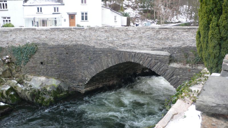
Bridge over river Leven. C17 or C18, with later widening. Stone rubble with
limestone coping. Segmental arch, slightly pointed to south, and straight
parapet. Plaque to north side records flood level of 3rd November 1898.
Listing NGR: SD3558684938
External links are from the relevant listing authority and, where applicable, Wikidata. Wikidata IDs may be related buildings as well as this specific building. If you want to add or update a link, you will need to do so by editing the Wikidata entry.


Other nearby listed buildings
