Approximate Location Map
Large Map »
Latitude: 54.2443 / 54°14'39"N
Longitude: -3.0062 / 3°0'22"W
OS Eastings: 334526
OS Northings: 483646
OS Grid: SD345836
Mapcode National: GBR 7MFC.Y9
Mapcode Global: WH834.SLN3
Plus Code: 9C6R6XVV+PG
Entry Name: Low Wood Bridge
Listing Date: 23 July 1987
Grade: II
Source: Historic England
Source ID: 1225415
English Heritage Legacy ID: 421791
ID on this website: 101225415
Location: Low Wood, Westmorland and Furness, Cumbria, LA12
County: Cumbria
District: South Lakeland
Civil Parish: Haverthwaite
Traditional County: Lancashire
Lieutenancy Area (Ceremonial County): Cumbria
Church of England Parish: Haverthwaite St Anne
Church of England Diocese: Carlisle
Tagged with: Bridge
HAVERTHWAITE B5278
SD 38 SW
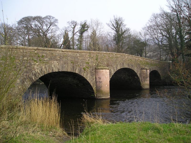
9/82 Low Wood Bridge
II
Bridge. C18 or early C19. Stone rubble. 3 elliptical arches with 2 round
cutwaters to each side, which are roughcast, with caps. Parapet has plain
coping. Probably associated with Low Wood ironworks, the site later taken over
for gunpowder works, of which the Clock Tower works (q.v.) remain.
Listing NGR: SD3452683646
External links are from the relevant listing authority and, where applicable, Wikidata. Wikidata IDs may be related buildings as well as this specific building. If you want to add or update a link, you will need to do so by editing the Wikidata entry.


Other nearby listed buildings
