Approximate Location Map
Large Map »
Latitude: 50.4315 / 50°25'53"N
Longitude: -3.687 / 3°41'13"W
OS Eastings: 280276
OS Northings: 60426
OS Grid: SX802604
Mapcode National: GBR QM.T6GQ
Mapcode Global: FRA 375X.7DR
Plus Code: 9C2RC8J7+H5
Entry Name: Eastgate (Part of No 2)
Listing Date: 7 January 1952
Grade: I
Source: Historic England
Source ID: 1236272
English Heritage Legacy ID: 427222
ID on this website: 101236272
Location: Totnes, South Hams, Devon, TQ9
County: Devon
District: South Hams
Civil Parish: Totnes
Built-Up Area: Totnes
Traditional County: Devon
Lieutenancy Area (Ceremonial County): Devon
Church of England Parish: Totnes St Mary
Church of England Diocese: Exeter
Tagged with: City gate
1.
5180 HIGH STREET
(South Side)
East gate
(Part of No 2)
SX 8060 SW 1/22 7.1.52.
I GV
2.
Totnes town defences The Anglo-Saxon borough defences probably enclosed the top
of the hill, commanding the navigable reaches of the Dart, on the line later followed
by the medieval wall, whose circuit is still marked by South Street, Guildhall Yard
and North Street. The motte and bailey castle (qv) built at the Conquest by Judhael
de Totnes was inserted at the highest point of the hill, in the north-west corner
of the Saxon burgh. The counterscarp of the defences of the inner bailey may preserve
the line of the borough curtilage. The 1st murage grant was received in 1264; a
2nd which was surrendered because nothing was being done, in 1355. The walls mainly
date to the late C14 with extensive repairs in 1639. Remains of the defences survive
at the North Gate, Castle Street; No 2, High Street; and the Baste Walls, South
Street (qv). The West Gate, formerly situated opposite No 79 High Street (qv) was
demolished circa 1810.
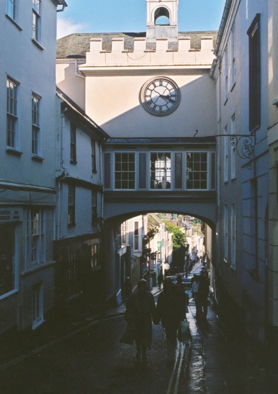
The East Gate Probably altered and refronted circa 1835 in Gothic style when the
former round-arched entrance and footway (the "needles eye") was replaced by a wide,
flat-arched gate-way. 2 storeys above archway. Welsh slate roof. Square wooden
bell turret with tented roof and weathervane. East front stuccoed with coved cornice
and crenellated parapet: string at 2nd floor level with clock above added circa
1880; splayed oriel window to 1st floor with crenellated parapet. 4-centred arched
gateway with hoodmould. West front also stuccoed with covedcornice and crenellated
parapet with clock belay: 1st floor with 3 sash windows with glazing bars, with
panels between and coved cornice. The room over the gate has early C16 linenfold
panelling and a frieze carved with reliefs of heads, grotesques and arabesques reputed
to have been brought from Berry Pomeroy Castle. The decorated plaster ceiling and
marble fireplace dates to circa 1835. In 1850 Lord Seymour purchased Gate House
and opened it as a Mechanic's Institute and Reading Room. The building now forms
part of the Berry Pomeroy estate office (No 2 High Street). [M. Laithwaite].
Listing NGR: SX8027660426
External links are from the relevant listing authority and, where applicable, Wikidata. Wikidata IDs may be related buildings as well as this specific building. If you want to add or update a link, you will need to do so by editing the Wikidata entry.


Other nearby listed buildings
