Approximate Location Map
Large Map »
Latitude: 52.3994 / 52°23'57"N
Longitude: 0.2648 / 0°15'53"E
OS Eastings: 554184
OS Northings: 280340
OS Grid: TL541803
Mapcode National: GBR M6H.FT1
Mapcode Global: VHHJ6.JYVJ
Plus Code: 9F4297X7+PW
Entry Name: 33 High Street
Listing Date: 8 November 1993
Last Amended: 18 November 2016
Grade: II
Source: Historic England
Source ID: 1252458
English Heritage Legacy ID: 435477
ID on this website: 101252458
Location: Ely, East Cambridgeshire, CB7
County: Cambridgeshire
District: East Cambridgeshire
Civil Parish: Ely
Built-Up Area: Ely
Traditional County: Cambridgeshire
Lieutenancy Area (Ceremonial County): Cambridgeshire
Church of England Parish: Ely
Church of England Diocese: Ely
Tagged with: Building
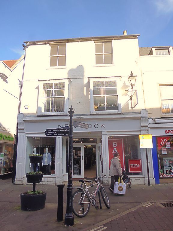
Shop; C13 or C14 and C16, substantially rebuilt and enlarged in the C18; extensively refurbished in the C19, ground floor remodelled in the C20.
DETAILS: shop; C13 or C14, and C16, originally timber framed, now mostly brick, substantially rebuilt and enlarged in the C18; extensively refurbished in the C19, the ground floor reconfigured to form a substantially open shop floor in the C20.
EXTERIOR: the building is constructed of brick with pitched slate roofs, and consists of a front range, the main elevation facing the street front, of two bays and three storeys, with a pitched roof. The first and second floors are separated by a storey band, with two four-paned sash windows to the second floor set under the eaves, and with two square bay windows, each with four paned sashes, to the first floor; these are set between the storey band and ground floor shop-front cornice. The C19 or early C20 shop front consists of plate glass windows with panelled surrounds, and with a cornice supported by console brackets. Between the windows is a wide, centrally placed entranceway, is also flanked by plate glass windows.
The rear range is also of three storeys. The west elevation faces onto the narrow High Street Passage and is in two sections, that to the south projecting forward slightly: each section has a sash window to first and second floors. At ground floor level, the south section has two full height display windows: the first of these has a similar surround to the south shop front, while the second, to the north of that, has a slightly bowed plate glass window flanked by slender plain pilasters, with plain, slight console brackets supporting a moulded entablature. The window to the north section is similar to the first in the south section.
INTERIOR: the ground floor consists mainly of a single open space, the shop floor, the ceilings of which are modern except for a section containing C16 timber beams and joists. This appears to have originally formed a middle bay of a building of at least four bays, which is likely to have had an open hall, and was at least partly jettied on its western side. The extent of the bay is defined to north and south by axial beams, the north beam elaborately moulded on its south side with a series of alternating rolls and cavettos, but with a plain chamfer on its north side. Towards the northern edge of the underside of the beam is a series of mortices for vertical studs, indicating the former presence of an internal partition dividing two separate spaces. The axial beam to the south has moulding on both sides, matching that to the south side of the north beam. A central spine beam runs between the two axial beams, with similar elaborate moulding; both ends of the beam have bar stops with inscribed foliate decoration.
To either side of the spine beam are a series of joists, also moulded with a double roll profile and run out stops. Of the seven joists to the west, six run into a jetty bressumer, just above the bow window. The position of the chamfer stops of four of these is about 50cm in from the window end of the joists, indicating the original wall line of the earlier building; between these stops and the bressumer the profile of the joists is a plain square. However, two of these six joists are not stopped until they meet the bressumer; the research report suggests this discrepancy may be the result of later removal and mis-replacement.
The undercroft is at present inaccessible (2016), as the entrance is beneath the shop sales counter. The 1993 List entry describes it as constructed of ashlar masonry with some brick, roughly rectangular in plan, measuring at least 16m from the front to the back wall and divided into three bays. An internal ashlar wall runs between the northern and central bay, the latter with a long round-headed arch, possibly for storage; it also states that there are several moulded beams to this chamber. The west wall of this bay is said to have two cuts to street level, one a stair, while the south bay has a square niche in the west wall and stone steps to the street in the south-west corner.
The present city of Ely rises 20m above the surrounding fen on an island of Kimmeridge clay. Although well connected by river and waterways, until the C17 only causeways connected the island to the mainland, and in the early years of Christianity its isolation made it an ideal refuge for those seeking a secluded monastic life. The first successful attempt to establish a religious settlement here was made by Etheldreda in c.673, re-endowed by King Edgar 100 years after its destruction by the Danes in 870. Despite threats of further invasion in the C11, and later political turmoil, this monastery survived until its dissolution in 1539. The presence of a monastic community occupying substantial buildings required the support of a lay community, and as that grew, so did the needs of the lay-people for accommodation and services. A detailed survey of 1416 recorded 457 buildings and described an established street pattern; by 1563 the number of households had grown to 800. Despite this growth in population, John Speed’s map of Ely, published in 1611/12, is very similar in both layout and extent to that of the first edition Ordnance Survey (OS) Map of 1885, where the only significant expansion is towards the railway (1845): however, in Speed’s map, houses lining the streets enclose spaces of apparently horticultural and even agricultural production, and while these are still present on the 1885 map they have been pushed to the margins of the city. These maps graphically illustrate the continuing importance of agriculture and agriculturally related industries in the early C17 and beyond, and also show that the later growth in population took place mainly within the confines of the early city street plan. Before the later C19, the only significant rival to agriculture was the pottery industry, in production from the C12 to 1860.
Following the dissolution of the monastery, Ely remained the centre of the diocese, but the loss of the community, and of pilgrims to the shrine of St Etheldreda, would have had a considerable impact on the city’s economy. The consequent decline in management of the fen and its waterways led to an increase in flooding, and attempts at drainage in the C17 and C18 seem to have had limited effect, creating constraints on the ability of the city to thrive. Successive literary travellers commented on the poor drainage, including Celia Fiennes in the mid-C17, who described the city as a “perfect quagmire”, and Daniel Defoe in the early C18, who noted both the city’s market gardens and its overflowing wells. By the mid-C19 the city was in a state of recovery and regeneration: several possible contributory factors include successful drainage, enclosure (1848) and the arrival of the railway with the opening of the Cambridge to Ely line in 1845. This was followed slightly later by other lines, making the city a transport hub. Despite this, the physical expansion of Ely beyond its medieval core was slow through the mid-C20, accelerating through the late C20 and into the C21, as Ely developed as a dormitory town for Cambridge.
33 High Street forms part of a largely continuous terrace of buildings on the north side of the High Street running from Lynn Road to the west to the Market Place in the east. It occupies a corner plot, between the street frontage to the south and a narrow passage to the west, which linked the High Street to Butcher’s Row and Market Street to the north; it seems likely that the area between the High Street and Market Street represents an infill of what was once a larger market place, originally stretching the full length of the present High Street. The process of market infill appears to have begun within the medieval period, and by the time of the 1416 survey of the town it is clear that there were continuous tenements running the length of the High Street.
The 1993 List entry for 33 High Street records the presence of C13 or C14 fabric in the undercroft, interpreted there as being associated with Ely Cathedral, but which the Historic England Research Report of 2016 suggests were built as a series of storage areas for shop units above, probably the earliest structures erected on this plot. These seem to have been replaced in the C16 by a four bay building, possibly including an open hall, which underwent some further alterations in the C17. Substantial rebuilding took place in the C18, with further refurbishment in the C19. The shop front dates to the late C19 or early C20, and the ground floor was significantly reconfigured in the C20.
33 High Street, Ely, is listed at Grade II for the following principal reasons:
* Architectural interest: of special interest for the medieval fabric and constructional detail of the undercroft, and for the retention on the ground floor of carved ceiling timbers dating to the C16, the detail of which allows for the theoretical reconstruction of the size, form and possibly the status of the building at that date. It is also of architectural interest for the survival of C18 fabric and detail, and for alterations into the early C20 that reflect changes in shop window design and fashion;
* Historic interest: the C13 or C14 fabric of the undercroft may confirm the early emergence of Ely’s street pattern, established by the early C15 and described on John Speed’s map of 1610/1611. Phases of rebuilding from the C16 onwards illustrate the city’s emerging townscape, and the evolution, distribution and role of commerce in the city up to the C18 into the C19 and C20;
* Survival: the undercroft appears to survive intact, and the elaborately carved timbers to the ground floor also form a complete ceiling bay of a C16 building. The C18 rebuilding survives largely intact, as do the late C19 or early C20 shop fronts;
* Group value: it lies within the Ely conservation area, and is one of 198 listed buildings in the city, forming part of a collection that illustrates building traditions spanning several centuries. It has group value with a number of listed buildings on the High Street, the closest of which are 21A and 23 High Street, 41 High Street, and the Sacristy Gate and Goldsmith’s Tower, all listed at Grade II.
External links are from the relevant listing authority and, where applicable, Wikidata. Wikidata IDs may be related buildings as well as this specific building. If you want to add or update a link, you will need to do so by editing the Wikidata entry.


Other nearby listed buildings
