Approximate Location Map
Large Map »
Latitude: 53.9551 / 53°57'18"N
Longitude: -1.0834 / 1°5'0"W
OS Eastings: 460243
OS Northings: 451390
OS Grid: SE602513
Mapcode National: GBR NQWP.7Y
Mapcode Global: WHFC3.BVBB
Plus Code: 9C5WXW48+2J
Entry Name: 52, Skeldergate
Listing Date: 14 February 1977
Grade: II
Source: Historic England
Source ID: 1256634
English Heritage Legacy ID: 464710
ID on this website: 101256634
Location: Clementhorpe, York, North Yorkshire, YO1
County: York
Electoral Ward/Division: Micklegate
Parish: Non Civil Parish
Built-Up Area: York
Traditional County: Yorkshire
Lieutenancy Area (Ceremonial County): North Yorkshire
Church of England Parish: York St Mary, Bishophill Junior
Church of England Diocese: York
Tagged with: Building
YORK
SE6051SW SKELDERGATE
1112-1/21/911 (South West side)
14/02/77 No.52
GV II
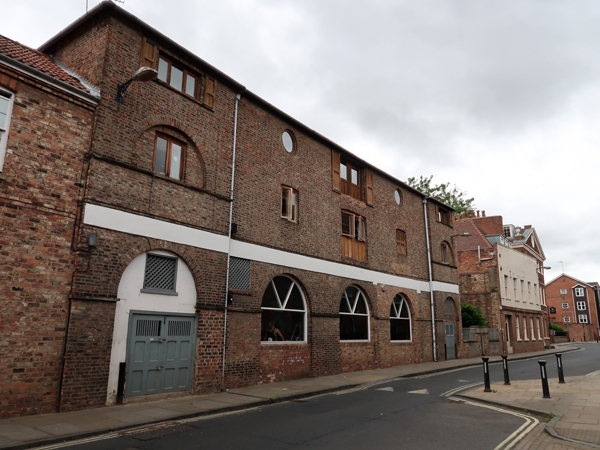
Sawmill and timber warehouse; now gymnasium. 1839; later
alteration. For John Henry Cattley. Pink mottled brick in
Flemish bond, with ashlar dressings; hipped roof of Welsh
slate, with wrought-iron corner brackets.
EXTERIOR: 3-storey 5-bay front, with slightly projecting end
bays. Ground floor arcade of five round arches, formerly open,
the end ones now closed by panelled double doors, centre ones
blocked by brick walling and C20 radial-glazed windows. Former
lifting door in centre of first floor, between segment-arched
windows, and semicircular blind recesses containing similar
windows in outer bays. On second floor, former lifting door in
centre between circular openings, and flat arched windows in
outer bays. Arcade impost band on ground floor; painted ashlar
first floor band; moulded ashlar sills to openings in first
and second floor outer bays.
INTERIOR: two massive cylindrical brick piers on ground floor.
Roof constructed of 7 king-post trusses of heavy scantling,
with raking struts and a ridge beam.
(City of York: RCHME: South-west of the Ouse: HMSO: 1972-:
102).
Listing NGR: SE6024351390
External links are from the relevant listing authority and, where applicable, Wikidata. Wikidata IDs may be related buildings as well as this specific building. If you want to add or update a link, you will need to do so by editing the Wikidata entry.


Other nearby listed buildings
