Approximate Location Map
Large Map »
Latitude: 53.953 / 53°57'10"N
Longitude: -1.0964 / 1°5'47"W
OS Eastings: 459395
OS Northings: 451140
OS Grid: SE593511
Mapcode National: GBR NQSQ.FQ
Mapcode Global: WHFC3.4W5Z
Plus Code: 9C5WXW33+5C
Entry Name: 1 and 2, Mount Parade
Listing Date: 14 June 1954
Last Amended: 14 March 1997
Grade: II
Source: Historic England
Source ID: 1257191
English Heritage Legacy ID: 464147
ID on this website: 101257191
Location: Clementhorpe, York, North Yorkshire, YO24
County: York
Electoral Ward/Division: Micklegate
Parish: Non Civil Parish
Built-Up Area: York
Traditional County: Yorkshire
Lieutenancy Area (Ceremonial County): North Yorkshire
Church of England Parish: York St Paul
Church of England Diocese: York
Tagged with: Building
YORK
SE5951SW MOUNT PARADE
1112-1/19/750 (North East side)
14/06/54 Nos.1 AND 2
(Formerly Listed as:
MOUNT PARADE
Nos.1-4 AND 5-18 (Consecutive))
GV II
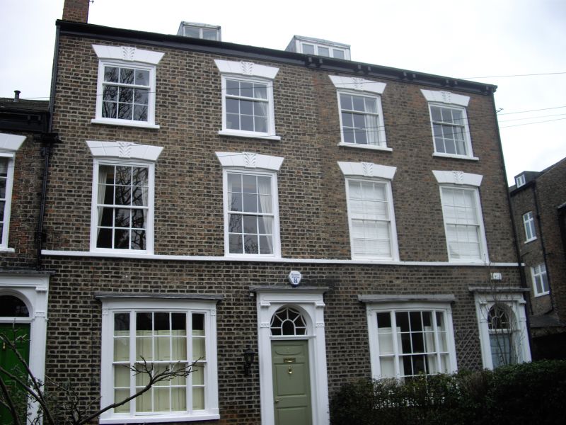
Two houses. 1823-8. Brick with some painted stone or stucco
dressings. Slate roof.
EXTERIOR: 3 storeys with attics and cellars. Each house of 2
bays. The windows are glazing bar sashes. On the ground floor
each house has a tripartite bowed window to the left and a
door to the right. The upper floor windows have painted
rusticated lintels with decorated false keystones and
segmental soffits, and there is a 1st floor sill band. The
cellars have casement windows in brick bows, and each house
has an attic dormer. The doorcases have reeded pilasters,
friezes with panels formed by raised borders, flattened
console brackets, and semicircular overlights. The overlight
to No.2 contains C20 coloured glass. The doors each have an
oval panel above 2 rectangular panels. No.1 has a timber
gutter on paired rectangular brackets. Chimneys between houses
and at left of No.2.
INTERIOR: not inspected.
(An Inventory of the Historical Monuments of the City of York:
RCHME: South-west of the Ouse: HMSO: 1972-: 128).
Listing NGR: SE5939551140
External links are from the relevant listing authority and, where applicable, Wikidata. Wikidata IDs may be related buildings as well as this specific building. If you want to add or update a link, you will need to do so by editing the Wikidata entry.


Other nearby listed buildings
