Approximate Location Map
Large Map »
Latitude: 53.9564 / 53°57'22"N
Longitude: -1.0905 / 1°5'25"W
OS Eastings: 459780
OS Northings: 451524
OS Grid: SE597515
Mapcode National: GBR NQTP.QH
Mapcode Global: WHFC3.6TZC
Plus Code: 9C5WXW45+GR
Entry Name: 128, 130 and 132, Micklegate
Listing Date: 14 June 1954
Grade: II
Source: Historic England
Source ID: 1257268
English Heritage Legacy ID: 464056
ID on this website: 101257268
Location: Clementhorpe, York, North Yorkshire, YO1
County: York
Electoral Ward/Division: Micklegate
Parish: Non Civil Parish
Built-Up Area: York
Traditional County: Yorkshire
Lieutenancy Area (Ceremonial County): North Yorkshire
Church of England Parish: Micklegate Holy Trinity
Church of England Diocese: York
Tagged with: Building
YORK
SE5951NE MICKLEGATE
1112-1/15/683 (North side)
14/06/54 Nos.128, 130 AND 132
GV II
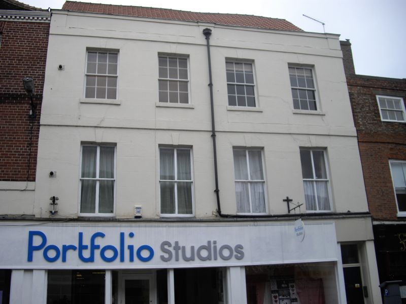
House. Mid C18; subdivided in early C19; C20 shopfront. Front
of stuccoed brick; right side of red brick in stretcher bond;
double-span roof of pantiles, partly obscured by parapet
broken by pilaster piers and with shallow moulded cornice.
EXTERIOR: 3-storey 4-window front. Shopfront continues on
ground floor of No.136 adjacent (qv); at right end, upstairs
access door of 6 panels, approached by two steps. Windows on
first and second floors are sashes, of 4 panes and 12 panes
respectively: all windows have keyed flat arches beneath the
stucco, and second floor windows have painted sills. 4-course
raised bands of brick to second floor and beneath parapet, the
latter returned at right end.
Rear: 3-storey 3-window centre block flanked by 3-storey
1-window projecting wings. Windows are sashes, either 4 panes
or 8 panes with flat arches of brick, most altered. Raised
brick bands across centre block and wings at first and second
floor levels.
INTERIOR: RCHM record fragments of original staircase with
turned and twisted balusters re-used in present staircase.
(City of York: RCHME: South-west of the Ouse: HMSO: 1972-:
94).
Listing NGR: SE5975251527
External links are from the relevant listing authority and, where applicable, Wikidata. Wikidata IDs may be related buildings as well as this specific building. If you want to add or update a link, you will need to do so by editing the Wikidata entry.


Other nearby listed buildings
