Approximate Location Map
Large Map »
Latitude: 53.9574 / 53°57'26"N
Longitude: -1.0881 / 1°5'17"W
OS Eastings: 459932
OS Northings: 451642
OS Grid: SE599516
Mapcode National: GBR NQVP.64
Mapcode Global: WHFC3.8S3K
Plus Code: 9C5WXW46+XQ
Entry Name: 58 and 60, Micklegate
Listing Date: 19 August 1971
Grade: II
Source: Historic England
Source ID: 1257342
English Heritage Legacy ID: 464004
ID on this website: 101257342
Location: York, North Yorkshire, YO1
County: York
Electoral Ward/Division: Micklegate
Parish: Non Civil Parish
Built-Up Area: York
Traditional County: Yorkshire
Lieutenancy Area (Ceremonial County): North Yorkshire
Church of England Parish: Micklegate Holy Trinity
Church of England Diocese: York
Tagged with: Building
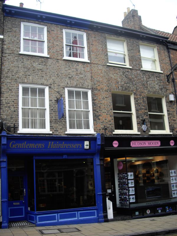
YORK
SE5951NE MICKLEGATE
1112-1/15/653 (North side)
19/08/71 Nos.58 AND 60
GV II
Two houses. No.58 late C18, refronted c1835, when No.60 was
rebuilt; shopfronts c1835. Pink and white mottled brick in
Flemish bond with timber eaves band; rear of No.58 in pale
brick with red brick dressings: Welsh slate roof with brick
stack at right end.
EXTERIOR: 3-storey 4-window front. Paired shopfronts have
fluted and panelled pilasters with dentilled cornice on fluted
corbel brackets over deep fascia. Shop doors are glazed and
panelled, deeply recessed to left of plate glass windows over
panelled risers. No.58 has 1-pane sashes on first and second
floors; No.60 has 12-pane sashes. All have painted stone sills
and flat arches of brick. Rear: tripartite sash windows with
segmental arches. No.58 has brick dentil eaves cornice.
INTERIOR: No.58 has round arch on panelled pilasters with
moulded imposts in entrance passage. Close string staircase to
third floor, with slender turned balusters and ramped-up,
moulded handrail wreathed at foot around turned newel on
shaped curtail step. No.60 has close string staircase with
slender turned balusters and large turned newels to second
half landing; above, balusters are square-section.
(City of York: RCHME: South-west of the Ouse: HMSO: 1972-:
78-79).
Listing NGR: SE5993551646
External links are from the relevant listing authority and, where applicable, Wikidata. Wikidata IDs may be related buildings as well as this specific building. If you want to add or update a link, you will need to do so by editing the Wikidata entry.


Other nearby listed buildings
