Approximate Location Map
Large Map »
Latitude: 51.3976 / 51°23'51"N
Longitude: 0.5348 / 0°32'5"E
OS Eastings: 576429
OS Northings: 169557
OS Grid: TQ764695
Mapcode National: GBR PPP.B0P
Mapcode Global: VHJLV.742F
Plus Code: 9F329GXM+2W
Entry Name: Main gate, lodge and walls to former HMS Pembroke
Listing Date: 6 June 1984
Last Amended: 5 December 1996
Grade: II
Source: Historic England
Source ID: 1267780
English Heritage Legacy ID: 462559
ID on this website: 101267780
Location: Brompton, Medway, Kent, ME4
County: Medway
Electoral Ward/Division: River
Parish: Non Civil Parish
Built-Up Area: Gillingham
Traditional County: Kent
Lieutenancy Area (Ceremonial County): Kent
Church of England Parish: Gillingham St Mark
Church of England Diocese: Rochester
Tagged with: Architectural structure
TQ7669NW
686-1/1/98
GILLINGHAM
Pembroke
DOCK ROAD (east side)
Main gate, lodge and walls to former HMS Pembroke
(Formerly Listed as: DOCK ROAD Main gate to HMS Pembroke Dock Road & walls Pembroke Rd, Dock Rd, Cumberland Rd)
(Formerly Listed as: CUMBERLAND ROAD (North side) Main gate to HMS Pembroke in Dock Rd, walls Pembroke Rd, Dock Rd, Cumberland Rd)
(Formerly Listed as: PEMBROKE ROAD (West side) Main gate to HMS Pembroke Dock Rd, walls... Pembroke Rd, Dock Rd, Cumberland Rd)
06/06/84
GV
II
Includes: Main gate, lodge and walls to former HMS Pembroke PEMBROKE ROAD. Includes: Main gate, lodge and walls to former HMS Pembroke CUMBERLAND ROAD.
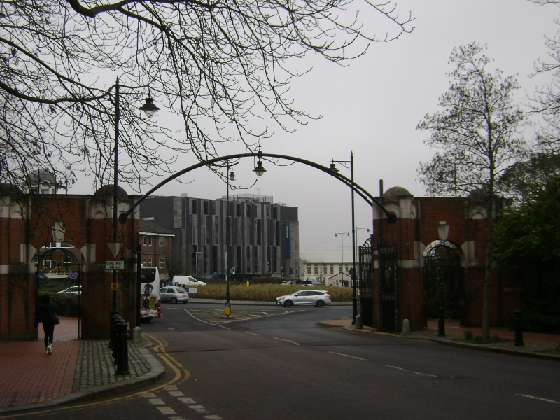
Gates, walls and lodge. c1902, by Sir Henry Pilkington, central pier removed c1990. Brick with stone dressings and slate roof.
Main gate has four diagonally-set piers to outer wickets and wide gateway, single-room lodge, and walls to right extend back approximately 40 metres. Piers have impost bands, sunken round-arched panels with cornices, attached square piers to a domed cap; outer round-arched wickets have split keystones and parapet over; wrought-iron gates with wreathed panels, four wrought-iron former main gates with dog rails and panels, all hung from piers, former central pier removed, and a late C20 steel overthrow across.
Lodge has clasping buttresses to a parapet, gabled ends, and single wide round-arched windows with mullions and glazing bars. Lateral stack. Railings have diagonal square piers with coved coping and railings with curved finials. Walls extend approximately 75 metres to north of main gate on Pembroke Road and 300 metres to south and south east on Dock Road and Cumberland Road: coved stone coping and tall buttress piers.
HISTORY: part of a carefully planned early C20 naval barracks, with the former Captain's House, Mess block, barracks and ancillary buildings (qqv).
Listing NGR: TQ7642569575
External links are from the relevant listing authority and, where applicable, Wikidata. Wikidata IDs may be related buildings as well as this specific building. If you want to add or update a link, you will need to do so by editing the Wikidata entry.


Other nearby listed buildings
