Approximate Location Map
Large Map »
Latitude: 54.198 / 54°11'52"N
Longitude: -2.8984 / 2°53'54"W
OS Eastings: 341484
OS Northings: 478395
OS Grid: SD414783
Mapcode National: GBR 8M6W.9X
Mapcode Global: WH83D.GR04
Plus Code: 9C6V54X2+5J
Entry Name: Two Follies in Wooded Cliff Above and Belonging to Netherwood Hotel
Listing Date: 2 May 1975
Grade: II
Source: Historic England
Source ID: 1269683
English Heritage Legacy ID: 460533
ID on this website: 101269683
Location: Grange-over-Sands, Westmorland and Furness, Cumbria, LA11
County: Cumbria
District: South Lakeland
Civil Parish: Grange-over-Sands
Traditional County: Lancashire
Lieutenancy Area (Ceremonial County): Cumbria
Church of England Parish: Grange-over-Sands St Paul
Church of England Diocese: Carlisle
Tagged with: Architectural structure
GRANGE-OVER-SANDS
SD47NW
705-1/2/25
02/05/75
LINDALE ROAD
(North side (off))
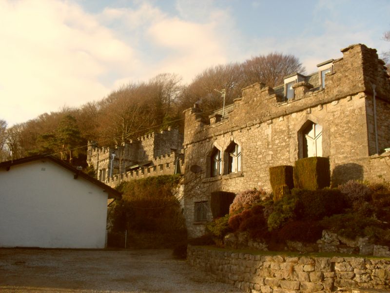
Two follies in wooded cliff, above
and belonging to Netherwood Hotel
GV
II
Two outbuildings, now houses. Probably mid C19. Originally
part of a group of garden buildings which included a
gardener's cottage, greenhouses, and a tool-shed. Now
converted into houses, with original openings retained and
with extensions in keeping. Limestone rubble with rough-cut
limestone dressings and slate roofs behind embattled parapets.
The western building includes a window facing south which has
a fixed light with glazing bars and intersecting glazing in
its triangular head. To the left is a corbelled round corner
turret. An embattled terrace wall forms a link with the
eastern building, which has 1st-floor window openings with
triangular heads, and a corbelled embattled parapet which
steps up towards the centre and at the sides.
HISTORY: Netherwood (now the Netherwood Hotel, (qv)) was built
in 1893 on the site of Blawith Cottage, which was built c1800
and may have been by Francis Webster. Although the garden
buildings appear to date from before 1893 they are not shown
on the 1st edition of the Six Inch Ordnance Survey Map, which
was surveyed in the late 1840s.
Listing NGR: SD4148478395
External links are from the relevant listing authority and, where applicable, Wikidata. Wikidata IDs may be related buildings as well as this specific building. If you want to add or update a link, you will need to do so by editing the Wikidata entry.


Other nearby listed buildings
