Approximate Location Map
Large Map »
Latitude: 54.1929 / 54°11'34"N
Longitude: -3.0969 / 3°5'48"W
OS Eastings: 328526
OS Northings: 478017
OS Grid: SD285780
Mapcode National: GBR 6MTY.BQ
Mapcode Global: WH725.DWH0
Plus Code: 9C6R5WV3+56
Entry Name: 18, Princes Street
Listing Date: 20 June 1972
Grade: II
Source: Historic England
Source ID: 1270214
English Heritage Legacy ID: 459999
ID on this website: 101270214
Location: Ulverston, Westmorland and Furness, Cumbria, LA12
County: Cumbria
District: South Lakeland
Civil Parish: Ulverston
Built-Up Area: Ulverston
Traditional County: Lancashire
Lieutenancy Area (Ceremonial County): Cumbria
Church of England Parish: Ulverston St Mary with Holy Trinity
Church of England Diocese: Carlisle
Tagged with: Building
ULVERSTON
SD2878 PRINCE'S STREET
626-1/3/99 (West side)
20/06/72 No.18
GV II
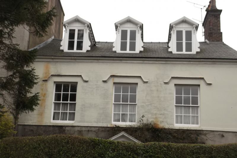
House. Early to mid C19. Possibly by Websters of Kendal.
Stucco with limestone ashlar plinth and 1st-floor sill band;
slate roof.
A symmetrical composition of 2 storeys plus attic and 3 bays.
The windows are glazing bar sashes with plain reveals (those
on the ground floor with low sills and 15 panes) and have
stucco hoodmoulds. The attic dormers are gabled, with
overhanging roofs carried on brackets, have scrolled brackets
to left and right of their casement windows, and have slated
cheeks. The door has 6 raised and fielded panels and a
fanlight and is set within a doorcase of engaged Tuscan
columns supporting an open pediment. It is approached by 3
external steps with nosings. Chimneys on right-hand gable, and
at left shared with No.20 (qv)
INTERIOR: the open-string dogleg staircase has stick balusters
and a wreathed mahogany handrail. The doors have panels with
borders formed by applied mouldings and reeded architraves.
HISTORICAL NOTE: the building plot later occupied by the house
is said to have been sold in 1813, and the house is shown on a
plan dated 1827.
Listing NGR: SD2852678017
External links are from the relevant listing authority and, where applicable, Wikidata. Wikidata IDs may be related buildings as well as this specific building. If you want to add or update a link, you will need to do so by editing the Wikidata entry.


Other nearby listed buildings
