Approximate Location Map
Large Map »
Latitude: 51.3657 / 51°21'56"N
Longitude: 1.4196 / 1°25'10"E
OS Eastings: 638131
OS Northings: 168513
OS Grid: TR381685
Mapcode National: GBR X06.CQM
Mapcode Global: VHMCP.KXBX
Plus Code: 9F339C89+7R
Entry Name: The Old Farm House
Listing Date: 24 January 1950
Grade: II
Source: Historic England
Source ID: 1273792
English Heritage Legacy ID: 417094
ID on this website: 101273792
Location: St Peter's, Thanet, Kent, CT10
County: Kent
District: Thanet
Civil Parish: Broadstairs and St. Peters
Built-Up Area: Broadstairs
Traditional County: Kent
Lieutenancy Area (Ceremonial County): Kent
Tagged with: Farmhouse
CHURCH STREET
1.
5283
(North West Side)
ST PETERS
No 13
(The Old Farm House)
TR 3868 NW 4/23 24.1.50.
II
2.
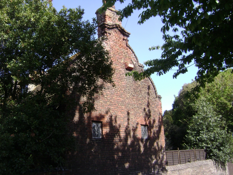
Main facade dated 1710, but the house is probably earlier, as it has a gabled brick
porch dated 1686 and a shaped Dutch gable at the east end, probably of the same
date. 2 storeys and attics red brick. Right side shaped Dutch gable. Tiled roof
with modern hipped dormer. 3 sashes with glazing bars intact.
Listing NGR: TR3813168513
External links are from the relevant listing authority and, where applicable, Wikidata. Wikidata IDs may be related buildings as well as this specific building. If you want to add or update a link, you will need to do so by editing the Wikidata entry.


Other nearby listed buildings
