Approximate Location Map
Large Map »
Latitude: 53.0173 / 53°1'2"N
Longitude: -1.7331 / 1°43'59"W
OS Eastings: 417999
OS Northings: 346705
OS Grid: SK179467
Mapcode National: GBR 48Q.SRJ
Mapcode Global: WHCF5.BFY5
Plus Code: 9C5W2788+WP
Entry Name: Lamp Post, Victoria Square
Listing Date: 14 February 1974
Grade: II
Source: Historic England
Source ID: 1279602
English Heritage Legacy ID: 79844
ID on this website: 101279602
Location: Ashbourne, Derbyshire Dales, Derbyshire, DE6
County: Derbyshire
District: Derbyshire Dales
Civil Parish: Ashbourne
Built-Up Area: Ashbourne
Traditional County: Derbyshire
Lieutenancy Area (Ceremonial County): Derbyshire
Church of England Parish: Ashbourne St Oswald
Church of England Diocese: Derby
Tagged with: Streetlight
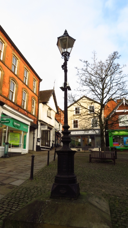
VICTORIA SQUARE
1.
783
Lamp Post
II
2.
l864. Ornate silvered cast iron lamp standard , erected by the Ashbourne Gas
Company in 1864. Now used as a support for the street's nameplate.
Listing NGR: SK1799946705
The entry has been subject to a Minor Amendment in 2016.
External links are from the relevant listing authority and, where applicable, Wikidata. Wikidata IDs may be related buildings as well as this specific building. If you want to add or update a link, you will need to do so by editing the Wikidata entry.


Other nearby listed buildings
