Approximate Location Map
Large Map »
Latitude: 51.2683 / 51°16'5"N
Longitude: 0.1942 / 0°11'38"E
OS Eastings: 553166
OS Northings: 154412
OS Grid: TQ531544
Mapcode National: GBR MN4.FWM
Mapcode Global: VHHPS.BD02
Plus Code: 9F32759V+8M
Entry Name: 28 and 30, High Street
Listing Date: 29 September 1972
Grade: II
Source: Historic England
Source ID: 1281307
English Heritage Legacy ID: 172187
ID on this website: 101281307
Location: Sevenoaks, Kent, TN13
County: Kent
District: Sevenoaks
Civil Parish: Sevenoaks
Built-Up Area: Sevenoaks
Traditional County: Kent
Lieutenancy Area (Ceremonial County): Kent
Church of England Parish: Sevenoaks St Nicholas
Church of England Diocese: Rochester
Tagged with: Building
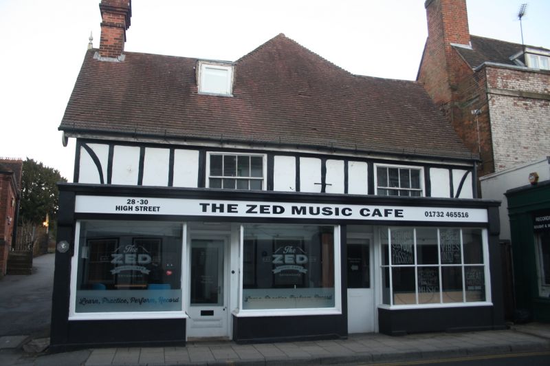
HIGH STREET
1.
1614
(East Side)
Nos 28 and 30
TQ 5354/1/12
II
2.
Probably a C17 framed structure but with later C18 elevational treatment.
Projecting Victorian shop fronts on ground floor. First floor stucco with
2 wide C18 sash windows with glazing bars in exposed frames. Eaves and
gutter. Ridge tile roof with small flat-leaded dormer to left.
Listing NGR: TQ5316654412
External links are from the relevant listing authority and, where applicable, Wikidata. Wikidata IDs may be related buildings as well as this specific building. If you want to add or update a link, you will need to do so by editing the Wikidata entry.


Other nearby listed buildings
