Approximate Location Map
Large Map »
Latitude: 51.2709 / 51°16'15"N
Longitude: 0.1918 / 0°11'30"E
OS Eastings: 552995
OS Northings: 154702
OS Grid: TQ529547
Mapcode National: GBR MN4.7B6
Mapcode Global: VHHPS.8BS1
Plus Code: 9F3275CR+9P
Entry Name: 2, Bank Street
Listing Date: 29 September 1972
Grade: II
Source: Historic England
Source ID: 1281419
English Heritage Legacy ID: 172152
ID on this website: 101281419
Location: Sevenoaks, Kent, TN13
County: Kent
District: Sevenoaks
Civil Parish: Sevenoaks
Built-Up Area: Sevenoaks
Traditional County: Kent
Lieutenancy Area (Ceremonial County): Kent
Church of England Parish: Sevenoaks St Nicholas
Church of England Diocese: Rochester
Tagged with: Building
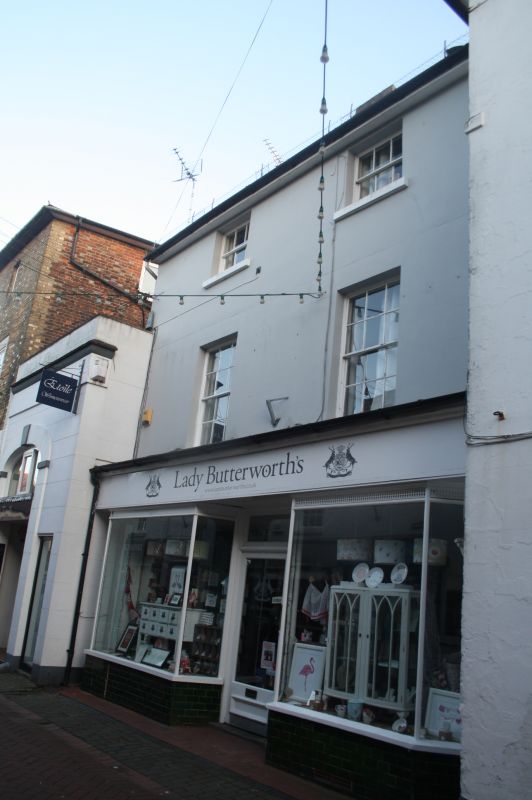
BANK STREET
1.
1614
No 2
TQ 5254/1/190
II GV
2.
Late C18 or early C19 stuccoed front of 2 storeys, 2 windows. Slated mansard
roof. Recessed sash windows with glazing bars. Late C19 double shop front
on ground floor.
[Forms a group with Nos 28 & 30 London Road.
Listing NGR: TQ5299554702
External links are from the relevant listing authority and, where applicable, Wikidata. Wikidata IDs may be related buildings as well as this specific building. If you want to add or update a link, you will need to do so by editing the Wikidata entry.


Other nearby listed buildings
