Approximate Location Map
Large Map »
Latitude: 51.8998 / 51°53'59"N
Longitude: -1.0677 / 1°4'3"W
OS Eastings: 464243
OS Northings: 222771
OS Grid: SP642227
Mapcode National: GBR 9YS.T1Q
Mapcode Global: VHCX5.FHXZ
Plus Code: 9C3WVWXJ+WW
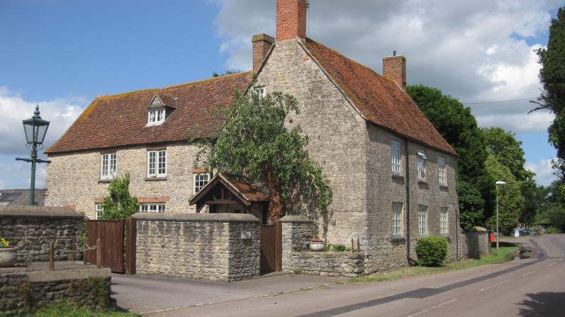
Entry Name: Pear Tree Farmhouse
Listing Date: 13 February 1984
Grade: II
Source: Historic England
Source ID: 1288477
English Heritage Legacy ID: 399545
ID on this website: 101288477
Location: Marsh Gibbon, Buckinghamshire, OX27
County: Buckinghamshire
Civil Parish: Marsh Gibbon
Built-Up Area: Marsh Gibbon
Traditional County: Buckinghamshire
Lieutenancy Area (Ceremonial County): Buckinghamshire
Church of England Parish: Marsh Gibbon
Church of England Diocese: Oxford
Tagged with: Farmhouse
SP 6422 MARSH GIBBON TOWNSEND
(north side)
9/61 Pear Tree Farmhouse
-
GV II
House. C18. Coursed rubble stone, old tile roof, flanking brick
stacks. L-plan. 2 storeys and attic, 3 bays. Paired C20
casements with stone voussoir heads. C20 door in left-hand gable
end. Rear wing has altered casements with brick heads.
RCHM II p. 193 Mon. 22.
Listing NGR: SP6424322771
External links are from the relevant listing authority and, where applicable, Wikidata. Wikidata IDs may be related buildings as well as this specific building. If you want to add or update a link, you will need to do so by editing the Wikidata entry.


Other nearby listed buildings
