Approximate Location Map
Large Map »
Latitude: 50.8467 / 50°50'48"N
Longitude: -2.7718 / 2°46'18"W
OS Eastings: 345761
OS Northings: 105527
OS Grid: ST457055
Mapcode National: GBR MH.VTVY
Mapcode Global: FRA 562V.PZG
Plus Code: 9C2VR6WH+M7
Entry Name: Church of St Mary
Listing Date: 22 December 1983
Grade: II
Source: Historic England
Source ID: 1289886
English Heritage Legacy ID: 396209
ID on this website: 101289886
Location: St Mary's Church, Mosterton, Dorset, DT8
County: Dorset
Civil Parish: Mosterton
Built-Up Area: Mosterton
Traditional County: Dorset
Lieutenancy Area (Ceremonial County): Dorset
Church of England Parish: Mosterton St Mary
Church of England Diocese: Salisbury
Tagged with: Church building
MOSTERTON MOSTERTON VILLAGE
ST 40 NE
2/237 CHURCH OF ST MARY
GV II
Parish Church. 1833 by Edmund Pearce, built on a new site. West Tower,
Nave, north porch, chancel. Ashlar stone walls, corrugated asbestos and
tile roofs. Stone gable-copings. West Tower, 3 stages, with clasping
buttresses for 2 stages. West door with pointed arch. Label with crude
head-stops. 3-light west window, with same label. Single-light bell-
openings with a label over. String cornice and plain parapet. Nave: 4
bays with right-angle buttresses. Single lancets and labels. North door
at centre of north side, moulded surround. 2-leaf pointed door with recess-
panels. Stone porch with stone seats, pitched slate roof and stone gable-
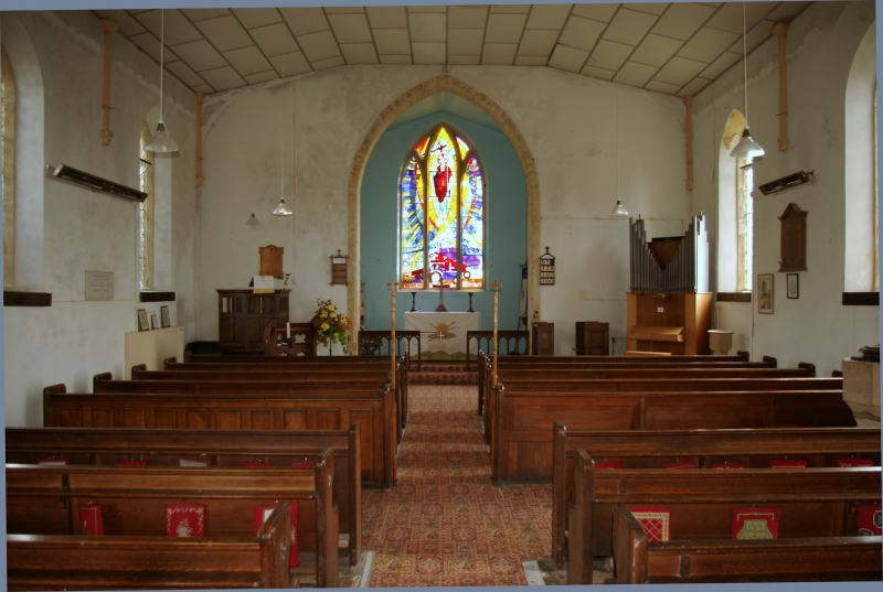
coping. Interior: pointed arch into tower. Plain splays to the lancets.
Lozenge-leading. Short wall-shafts stand on head-stops. Canted ceiling.
Chancel-arch, pointed with a straight chamfer, stopped. Short chancel,
with a 3-light east window (lancets). Fittings: wooden gallery at west end
standing on 4 reeded columns. Stained glass, C20, in east window: Risen
Christ over the agricultural community, ie a combine harvester, tractor
ploughing.
Source: RCHM Dorset I, p170(1).
Listing NGR: ST4576105527
External links are from the relevant listing authority and, where applicable, Wikidata. Wikidata IDs may be related buildings as well as this specific building. If you want to add or update a link, you will need to do so by editing the Wikidata entry.


Other nearby listed buildings
