Approximate Location Map
Large Map »
Latitude: 51.6383 / 51°38'17"N
Longitude: -0.6702 / 0°40'12"W
OS Eastings: 492121
OS Northings: 194109
OS Grid: SU921941
Mapcode National: GBR F6K.CC7
Mapcode Global: VHFSN.B2JY
Plus Code: 9C3XJ8QH+8W
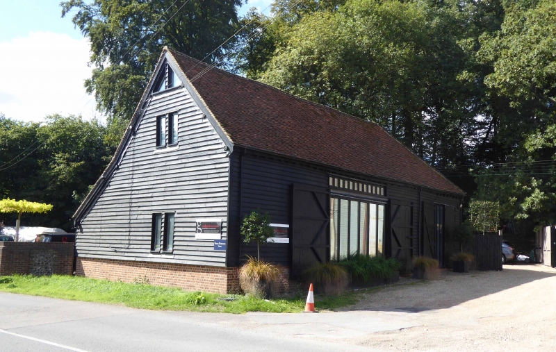
Entry Name: Barn to North West of Pennhouse Farmhouse
Listing Date: 17 March 1982
Grade: II
Source: Historic England
Source ID: 1309623
English Heritage Legacy ID: 44549
ID on this website: 101309623
Location: Buckinghamshire, HP10
County: Buckinghamshire
Civil Parish: Penn
Traditional County: Buckinghamshire
Lieutenancy Area (Ceremonial County): Buckinghamshire
Church of England Parish: Penn
Church of England Diocese: Oxford
Tagged with: Barn
PENN PENN BOTTOM
1.
5134
Barn to north-west of
SU 99 SW 3/53 Pennhouse Farmhouse
II GV
2.
C18/C19. Timber framed weather-boarded 3 bay barn with full height porch on
south side, and outshuts each side under continuation of main roof; tiles.
Listing NGR: SU9212994107
External links are from the relevant listing authority and, where applicable, Wikidata. Wikidata IDs may be related buildings as well as this specific building. If you want to add or update a link, you will need to do so by editing the Wikidata entry.


Other nearby listed buildings
