Approximate Location Map
Large Map »
Latitude: 54.5675 / 54°34'2"N
Longitude: -1.2404 / 1°14'25"W
OS Eastings: 449207
OS Northings: 519403
OS Grid: NZ492194
Mapcode National: GBR MHSM.7G
Mapcode Global: WHD6Z.XGHC
Plus Code: 9C6WHQ85+XR
Entry Name: Forbes' Buildings
Listing Date: 28 July 1988
Grade: II
Source: Historic England
Source ID: 1312528
English Heritage Legacy ID: 59749
ID on this website: 101312528
Location: Middlesbrough, North Yorkshire, TS1
County: Middlesbrough
Electoral Ward/Division: Newport
Parish: Non Civil Parish
Built-Up Area: Middlesbrough
Traditional County: Yorkshire
Lieutenancy Area (Ceremonial County): North Yorkshire
Church of England Parish: Middlesbrough All Saints
Church of England Diocese: York
Tagged with: Building
MIDDLESBROUGH LINTHORPE ROAD,
NZ 41 NE (4919)
west side.
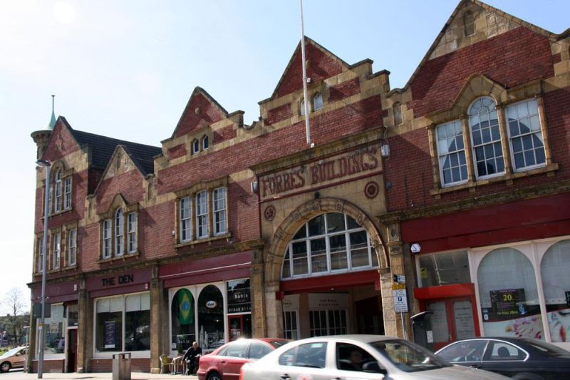
3/50 Forbes' Buildings
- II
Bakery with shops and offices, 1899/1900 by R. Lofthouse & Sons
(Middlesbrough), for John Forbes. Now used as shopping arcade. Brick in
English garden wall bond, with terracotta dressings. Late C20 concrete-
tiled roofs, and glazed roof over arcades. Asymmetrical front. Mixed
Classical and Gothic styles. 2-and 3-storey, 8-bay entrance front. 4th bay
has round-headed vehicle entrance, with fanlight, imposts and archivolt with
enriched key blocks and roundels in spandrels, under deep frieze with
applied lettering: "FORBES' BUILDINGS", and cornice. Other bays have
renewed late C20 shop fronts, framed by original pilasters and cornice. 3
sash windows, on upper floors of each bay, with quoin surrounds or grouped
with pilasters. Venetian windows on 2nd floors of first and 6th bays and on
first floor of 2nd, 5th and 7th bays. Bracketed sills and plain lintel
bands. Shaped gable over each bay, with paired trefoil-headed attic windows
under floating cornices in 3rd, 4th and 8th bays. Blind round-headed niches
between bays. Round turret, with blind round arcading and bracketed
trumpet-shaped copper roof, rises from curved left corner. Similar 2-bay
right return. 10-bay left return shows similar but restrained treatment.
Rebuilt late C20 service area on north-west part of site is not of special
interest.
Listing NGR: NZ4920719403
External links are from the relevant listing authority and, where applicable, Wikidata. Wikidata IDs may be related buildings as well as this specific building. If you want to add or update a link, you will need to do so by editing the Wikidata entry.


Other nearby listed buildings
