Approximate Location Map
Large Map »
Latitude: 54.3246 / 54°19'28"N
Longitude: -0.9251 / 0°55'30"W
OS Eastings: 470008
OS Northings: 492648
OS Grid: SE700926
Mapcode National: GBR PLZF.JH
Mapcode Global: WHF9F.RKNJ
Plus Code: 9C6X83FF+RX
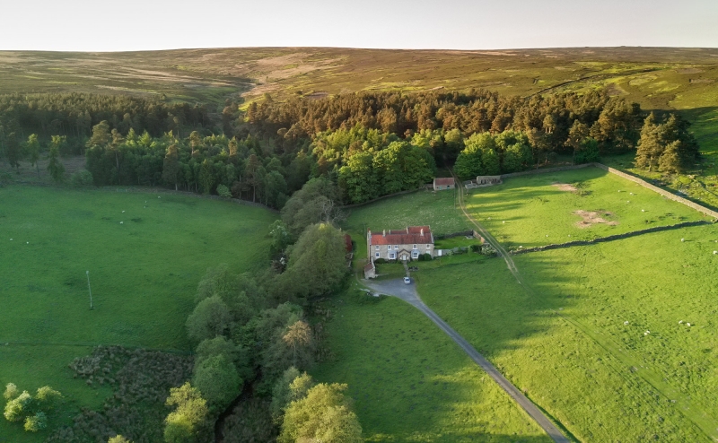
Entry Name: Spaunton Lodge
Listing Date: 24 June 1987
Grade: II
Source: Historic England
Source ID: 1316036
English Heritage Legacy ID: 328910
ID on this website: 101316036
Location: North Yorkshire, YO62
County: North Yorkshire
District: Ryedale
Civil Parish: Hutton-le-Hole
Traditional County: Yorkshire
Lieutenancy Area (Ceremonial County): North Yorkshire
Church of England Parish: Lastingham St Mary
Church of England Diocese: York
Tagged with: Gatehouse
HUTTON-LE-HOLE LODGE ROAD
SE 79 SW
(east side)
7/74 Spaunton Lodge
- II
Shooting box. 1770 on reset datestone; extended c1850. For the Darley
family. Herringbone-tooled sandstone to front; roughly tooled and hammer-
dressed sandstone to rear. Pantile roof with rebuilt brick stacks. Double-
depth, central-stairhall plan. 2-storey, 5-bay front, with single-storey
gabled porch added to centre. Porch, approached by stone steps, encloses
door of 6 recessed panels beneath blind fanlight in round-arched surround
with impost band; unequal 6-pane sashes to left and right. 3-window canted
bays with half-hexagonal roofs added to left and right of porch. Remaining
windows are 16-pane sashes, that to ground floor right inserted later. All
windows have painted stone sills and plain surrounds. Coped gables to roof
and rudimentary kneeler to left; coped gable and kneelers to porch. End
left and centre left and right stacks to front range of M-shaped roof.
Rear: board door to right beneath divided overlight, with datestone
incorporated in lintel. Oval panel to centre inscribed: M B D
E S Q
1770
with foliate decoration in low relief to left and right. Left side: paired
gable ends, of 2-storeys and basement. To right, an elliptical carriage
arch of shaped voussoirs, now blocked.
Listing NGR: SE7000892648
External links are from the relevant listing authority and, where applicable, Wikidata. Wikidata IDs may be related buildings as well as this specific building. If you want to add or update a link, you will need to do so by editing the Wikidata entry.


Other nearby listed buildings
