Approximate Location Map
Large Map »
Latitude: 54.5327 / 54°31'57"N
Longitude: -2.6788 / 2°40'43"W
OS Eastings: 356168
OS Northings: 515482
OS Grid: NY561154
Mapcode National: GBR 9JQ0.TX
Mapcode Global: WH81Y.TBJH
Plus Code: 9C6VG8MC+3F
Entry Name: The Hermitage
Listing Date: 6 February 1968
Grade: II
Source: Historic England
Source ID: 1326750
English Heritage Legacy ID: 74172
ID on this website: 101326750
Location: Shap, Westmorland and Furness, Cumbria, CA10
County: Cumbria
District: Eden
Civil Parish: Shap
Built-Up Area: Shap
Traditional County: Westmorland
Lieutenancy Area (Ceremonial County): Cumbria
Church of England Parish: Shap with Swindale St Michael
Church of England Diocese: Carlisle
Tagged with: Architectural structure
SHAP MAIN STREET
NY 5614/5 (West side), Shap
27/157 The Hermitage
6.2.68
II
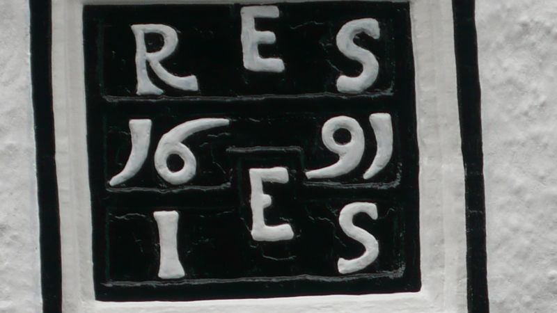
House; dated 1691 on panel over door with initials RES and IES (for
Ellwood?). Later additions and alterations. Wet-dashed rubble. 45° graduated
slate roofs with stone ridge. U-shaped plan; 2 storeys, 6 bays (1:4:1). C19
panelled door to central block in architrave with embattled lintel; 2 windows to
left and one to right. Dated panel between floors in corniced frame. Three lst-
floor windows. All windows sashes with glazing bars in original (former
mullioned 2-light) chamfered surrounds under continuous hoodmoulds; eaves
cornice. North wing: Sash with small lancet above, both C19; blocked ogee
window head on north return, C20 casement inserted in original chamfered
(3-light) opening on south return. South wing: Fixed window inserted in door
surround with small lancet above, both C19. Decorative C19 barge-boards with
pendants and finials to both wings; weather-vane to north wing. Corniced stone
mid and end chimneys.
Listing NGR: NY5616815482
External links are from the relevant listing authority and, where applicable, Wikidata. Wikidata IDs may be related buildings as well as this specific building. If you want to add or update a link, you will need to do so by editing the Wikidata entry.


Other nearby listed buildings
