Approximate Location Map
Large Map »
Latitude: 53.0176 / 53°1'3"N
Longitude: -1.7317 / 1°43'54"W
OS Eastings: 418094
OS Northings: 346736
OS Grid: SK180467
Mapcode National: GBR 48Q.T5C
Mapcode Global: WHCF5.CDMZ
Plus Code: 9C5W2799+38
Entry Name: 38 and 40, St John's Street
Listing Date: 14 February 1974
Grade: II
Source: Historic England
Source ID: 1335156
English Heritage Legacy ID: 79919
ID on this website: 101335156
Location: Ashbourne, Derbyshire Dales, Derbyshire, DE6
County: Derbyshire
District: Derbyshire Dales
Civil Parish: Ashbourne
Built-Up Area: Ashbourne
Traditional County: Derbyshire
Lieutenancy Area (Ceremonial County): Derbyshire
Church of England Parish: Ashbourne St Oswald
Church of England Diocese: Derby
Tagged with: Building
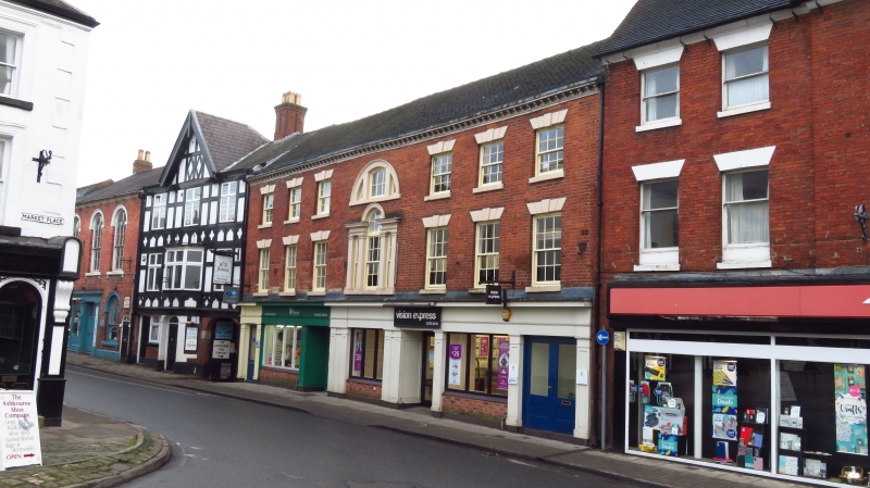
ST JOHN'S STREET
1.
783
(South-East Side)
SK 14 NE 1/198 Nos 38 & 40
II GV
2.
C18. Red brick with tiled roof. 3 storeys, 6 windows, all late sashes without
glazing bars. Modern shop front. Grade II for important focal position at bottom
of the Market Place.
No 2 and Nos 6 to 44 (even) form a group.
Listing NGR: SK1809446736
External links are from the relevant listing authority and, where applicable, Wikidata. Wikidata IDs may be related buildings as well as this specific building. If you want to add or update a link, you will need to do so by editing the Wikidata entry.


Other nearby listed buildings
