Approximate Location Map
Large Map »
Latitude: 51.237 / 51°14'13"N
Longitude: 0.7194 / 0°43'9"E
OS Eastings: 589929
OS Northings: 152156
OS Grid: TQ899521
Mapcode National: GBR QT6.8PX
Mapcode Global: VHKK5.F55L
Plus Code: 9F326PP9+QP
Entry Name: Mounting Block Circa 23 Yards North of Church of St Mary
Listing Date: 14 December 1984
Grade: II
Source: Historic England
Source ID: 1344264
English Heritage Legacy ID: 173951
ID on this website: 101344264
Location: Lenham, Maidstone, Kent, ME17
County: Kent
District: Maidstone
Civil Parish: Lenham
Built-Up Area: Lenham
Traditional County: Kent
Lieutenancy Area (Ceremonial County): Kent
Tagged with: Mounting block
LENHAM OLD ASHFORD ROAD
TQ 8952
(south side)
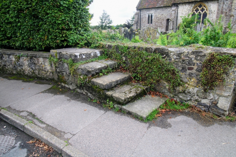
10/215 Mounting Block circa
23 yards north of
Church of St. Mary
GV II
Mounting block. Ragstone with large stone flag steps. 5 steps
parallel to churchyard wall, rising to height of about 3'.
Listing NGR: TQ8992952156
External links are from the relevant listing authority and, where applicable, Wikidata. Wikidata IDs may be related buildings as well as this specific building. If you want to add or update a link, you will need to do so by editing the Wikidata entry.


Other nearby listed buildings
